Geolocate

Westwood topographic map

Click on the map to display elevation.

About this map

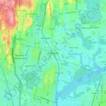
Name: Westwood topographic map, elevation, terrain.

Location: Westwood, Bergen County, New Jersey, 07630, United States (40.95121 -74.07264 41.03121 -73.99264)

Average elevation: 31 m

Minimum elevation: 3 m

Maximum elevation: 125 m

Gear up for your next adventure:

🧼Travel Hand Sanitizer - Keep hands clean when water is scarce
🚲Heavy Duty Bike Lock - Secure your bike at the trailhead or during stops
🧥Waterproof Hiking Jacket - Protect yourself from rain and wind while hiking
🥾Trail Running Boots - Durable shoes designed for trail running
Camping Essentials - All-in-one gear for a comfortable camping trip

As an Amazon Associate, this site earns from qualifying purchases at no extra cost to you.