
Make a donation
Gear up for your next adventure:
As an Amazon Associate, this site earns from qualifying purchases at no extra cost to you.
Ilha da Queimada Grande topographic map
Click on the map to display elevation.
Make a donation
Gear up for your next adventure:
As an Amazon Associate, this site earns from qualifying purchases at no extra cost to you.
Ilha da Queimada Grande
Located approximately 33 kilometres (21 mi) off the coast of the state of São Paulo, Brazil, the island of Queimada Grande is approximately 430,000 square metres (106 acres) in area and ranges in elevation from 0 to 206 metres (676 ft) above sea level. It has a temperate climate that is similar to that of its neighbouring island Nimer. Rainforest covers 0.25 square kilometres (62 acres) of the island, with the remaining area consisting of barren rocks and open grassland. Queimada Grande ranges from an average of 18.38 °C (65.08 °F) in August to 27.28 °C (81.10 °F) in March, and rainfall ranges from 0.2 millimetres (0.0079 in) per month in July to 135.2 millimetres (5.32 in) in December.
Make a donation
Gear up for your next adventure:
As an Amazon Associate, this site earns from qualifying purchases at no extra cost to you.
About this map
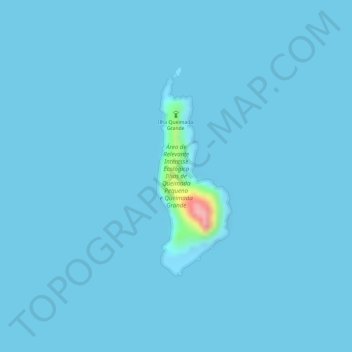
Name: Ilha da Queimada Grande topographic map, elevation, terrain.
Average elevation: 3 m
Minimum elevation: -2 m
Maximum elevation: 131 m
Make a donation
Gear up for your next adventure:
As an Amazon Associate, this site earns from qualifying purchases at no extra cost to you.
Other topographic maps
Click on a map to view its topography, its elevation and its terrain.
São Paulo
Brazil > São Paulo > Região Metropolitana de São Paulo > São Paulo
São Paulo is in Southeastern Brazil, in southeastern São Paulo State, approximately halfway between Curitiba and Rio de Janeiro. The city is on a plateau placed beyond the Serra do Mar (Portuguese for "Sea Range" or "Coastal Range"), itself a component of the vast region known as the Brazilian Highlands,…
Average elevation: 785 m
Várzea Paulista
Várzea Paulista is a municipality in the state of São Paulo in Brazil. The population is 123,071 (2020 est.) in an area of 35.1 km2. The elevation is 745 m. It is part of the agglomeration of Jundiaí.
Average elevation: 785 m
São Paulo
The city is on a plateau placed beyond the Serra do Mar (Portuguese for "Sea Range" or "Coastal Range"), itself a component of the vast region known as the Brazilian Highlands, with an average elevation of around 799 meters (2,621 ft) above sea level, although being at a distance of only about 70 kilometers…
Average elevation: 716 m
São Roque
São Roque (meaning Saint Roch in Portuguese) is a city in the state of São Paulo in Brazil. It is part of the Metropolitan Region of Sorocaba. The population is 92,060 (2020 est.) in an area of 306.91 km2 (118.50 sq mi). The city is at an altitude of 771 m. São Roque is connected by two main highways:…
Average elevation: 845 m
Make a donation
Gear up for your next adventure:
As an Amazon Associate, this site earns from qualifying purchases at no extra cost to you.
Sorocaba
The terrain is classified as a wavy strands and characterized by local ridges, with an average altitude of 632 meters above the sea level. The highest altitude is 1028 meters, in the Serra de Sao Francisco. The lower altitude is 539 meters, in the valley of the Sorocaba River. Sorocaba is located on the edge…
Average elevation: 625 m
Campinas
Brazil > São Paulo > Região Metropolitana de Campinas
This water tower was built between 1936 and 1940 in the highest altitude point inside the urban area, 735 meters above sea level. From its gazebo on the top, one can enjoy a wide panorama view of the city.
Average elevation: 666 m
Make a donation
Gear up for your next adventure:
As an Amazon Associate, this site earns from qualifying purchases at no extra cost to you.
São Paulo
São Paulo is located in Southeastern Brazil, in southeastern São Paulo State, approximately halfway between Curitiba and Rio de Janeiro. The city is located on a plateau located beyond the Serra do Mar (Portuguese for "Sea Range" or "Coastal Range"), itself a component of the vast region known as the…
Average elevation: 716 m
Registro
Registro is a city near the Atlantic coast of São Paulo, Brazil. The population is 56,393 (2020 est.) in an area of 722 km2. The elevation is 25 m. Registro in Portuguese means register, and this name was given to the city because it was the port from which the earlier settlers registered the gold that was…
Average elevation: 34 m
São Paulo
The city is on a plateau placed beyond the Serra do Mar (Portuguese for "Sea Range" or "Coastal Range"), itself a component of the vast region known as the Brazilian Highlands, with an average elevation of around 799 meters (2,621 ft) above sea level, although being at a distance of only about 70 kilometers…
Average elevation: 716 m
Make a donation
Gear up for your next adventure:
As an Amazon Associate, this site earns from qualifying purchases at no extra cost to you.
São Paulo
The city is on a plateau placed beyond the Serra do Mar (Portuguese for "Sea Range" or "Coastal Range"), itself a component of the vast region known as the Brazilian Highlands, with an average elevation of around 799 meters (2,621 ft) above sea level, although being at a distance of only about 70 kilometers…
Average elevation: 716 m
Leme
Brazil > São Paulo > Região Metropolitana de Piracicaba
Its average altitude is 619 meters above sea level (2030.8 ft). The relief is lightly wavy in the urban area and in most of rural area, which makes the urban expansion and the agricultural cultivation easier, as well as the transport by bicycle (cheap and non-polluting). This kind of transport is very common…
Average elevation: 652 m
Make a donation
Gear up for your next adventure:
As an Amazon Associate, this site earns from qualifying purchases at no extra cost to you.
Piracicaba
Brazil > São Paulo > Região Metropolitana de Piracicaba
The terrain of Piracicaba is predominantly rugged, with a notable depression in the central part of its territory. This depression extends along the east-west course of the Piracicaba River, becoming more pronounced within the urban area at the river's waterfall. This region separates the watersheds of the…
Average elevation: 570 m
Parque Estadual da Cantareira
Brazil > São Paulo > Região Metropolitana de São Paulo > São Paulo
There are four visitor centers: Pedra Grande, Engordador, Águas Claras and Cabuçu. The Pedra Grande center has a lookout over the city at 1,010 metres (3,310 ft) of altitude. The park is open for scheduled school groups during the week, and to the general public on weekends. It is an important leisure…
Average elevation: 841 m
Itatiba
Brazil > São Paulo > Região Metropolitana de Campinas
Itatiba is a municipality in the state of São Paulo in Brazil, approximately 80 km from the State Capital. It is part of the Metropolitan Region of Campinas. The population in 2022 was 121 590 in an area of 322.269 km². The average elevation is 750 m. The place's name comes from the Tupi Guarani language,…
Average elevation: 802 m
São Carlos
Its altitude is over 856 m. Most of the year the city is windy and sunny, with hot temperatures during all the year.
Average elevation: 692 m
Make a donation
Gear up for your next adventure:
As an Amazon Associate, this site earns from qualifying purchases at no extra cost to you.
São João da Boa Vista
São João da Boa Vista (Portuguese pronunciation: [ˈsɐ̃w ʒuˈɐ̃w dɐ ˈboɐ ˈvistɐ]; "Saint John of the Good View" in English) is a municipality in the state of São Paulo, Brazil. The population in 2020 was 91,771 and the area is 516.399 square kilometres (199.383 sq mi). The elevation is 767 metres (2,516 ft).
Average elevation: 866 m
Make a donation
Gear up for your next adventure:
As an Amazon Associate, this site earns from qualifying purchases at no extra cost to you.
Cachoeira Paulista
Brazil > São Paulo > Região Metropolitana do Vale do Paraíba e Litoral Norte
It is located at latitude 22º39'54 "south and longitude 45º00'34" west, being at an altitude of 521 meters. Its estimated population in 2020 was 33,581 inhabitants.
Average elevation: 675 m
Bonsucesso
Brazil > São Paulo > Região Metropolitana de São Paulo > Guarulhos
Average elevation: 777 m
Ilhabela
Brazil > São Paulo > Região Metropolitana do Vale do Paraíba e Litoral Norte
Throughout the 19th century, activities concerning sugarcane began to decay, but they were soon replaced by coffee, following a trend seen around the rest of the Paraíba Valley. Production concentrated in Ponta do Boi, in the south part of the island, more precisely at Nossa Senhora das Galhetas, Figueira e…
Average elevation: 116 m
Make a donation
Gear up for your next adventure:
As an Amazon Associate, this site earns from qualifying purchases at no extra cost to you.
São Paulo
The city is on a plateau placed beyond the Serra do Mar (Portuguese for "Sea Range" or "Coastal Range"), itself a component of the vast region known as the Brazilian Highlands, with an average elevation of around 799 meters (2,621 ft) above sea level, although being at a distance of only about 70 kilometers…
Average elevation: 716 m
Campos do Jordão
The city's economy is based mainly on tourism; due to its location at high elevation in the Mantiqueira Mountains, and traditional European-style architecture. Buildings are mostly vernacular architecture from German, Swiss, or Italian models. Many of the wealthiest residents in the state of São Paulo have…
Average elevation: 1,358 m
Vargem Grande Paulista
Brazil > São Paulo > Região Metropolitana de São Paulo
Average elevation: 900 m
Make a donation
Gear up for your next adventure:
As an Amazon Associate, this site earns from qualifying purchases at no extra cost to you.
Pedra do Baú
Brazil > São Paulo > Região Metropolitana do Vale do Paraíba e Litoral Norte > São Bento do Sapucaí
At its highest point, the elevation is 1,950 metres (6,400 ft).
Average elevation: 1,502 m
District of Jardim Presidente Dutra
Brazil > São Paulo > Região Metropolitana de São Paulo > Guarulhos
Average elevation: 772 m
Mauá
Brazil > São Paulo > Região Metropolitana de São Paulo
The city has a special characteristic hydrographic: not be crossed by any water course from another city, since, due to the high altitude, all streams that cross the territory of Mauá has their sources inside the city limits.
Average elevation: 805 m
Osasco
Brazil > São Paulo > Região Metropolitana de São Paulo
Osasco has an average elevation of 792 metres (2,598 ft) and an area of 64.95 km2 (25.08 sq mi). Its borders São Paulo to the north, east, and south, Cotia to the southwest, Carapicuíba and Barueri to the west, and Santana de Parnaíba to the northwest.
Average elevation: 768 m
Make a donation
Gear up for your next adventure:
As an Amazon Associate, this site earns from qualifying purchases at no extra cost to you.
Santo Antônio da Alegria
Brazil > São Paulo > Região Metropolitana de Ribeirão Preto
Santo Antônio da Alegria is a municipality in the northern part of the state of São Paulo in Brazil. The population is 6,977 (2020 est.) in an area of 310.29 km2 (119.80 sq mi). The elevation is 791 m. A neighboring municipality is São Sebastião do Paraíso in Minas Gerais to the northeast.
Average elevation: 898 m
Pindamonhangaba
Brazil > São Paulo > Região Metropolitana do Vale do Paraíba e Litoral Norte
Average elevation: 810 m
Barra do Turvo
Barra do Turvo is a municipality in the state of São Paulo in Brazil. The population is 7,632 (2020 est.) in an area of 1,008 km2 (389 sq mi). The elevation is 158 m (518 ft).
Average elevation: 597 m
Make a donation
Gear up for your next adventure:
As an Amazon Associate, this site earns from qualifying purchases at no extra cost to you.
Ubatuba
Brazil > São Paulo > Região Metropolitana do Vale do Paraíba e Litoral Norte
Average elevation: 503 m
Mata de Santa Genebra
Brazil > São Paulo > Região Metropolitana de Campinas > Campinas
Altitude ranges from 585 to 615 metres (1,919 to 2,018 ft). The terrain mainly takes the form of shallow sloped hollows holding deep and mature clay soils. Temperatures range from 0 to 38 °C (32 to 100 °F) with an average of 22 °C (72 °F). The unit is in the Atlantic Forest biome. 92% of the area is…
Average elevation: 610 m
Morro do Diabo
Brazil > São Paulo > Teodoro Sampaio
Its summit altitude is 650 metres (2,130 ft) (ASL). Morro do Diabo is an area landmark, seen from the valleys and plains below it. It is located near the cities of Caxias do Sul and Porto Alegre, the state capital.
Average elevation: 397 m
Parque Estadual Intervales
The name Intervales means "between the valleys", and refers to the park's location on the top of the Serra de Paranapiacaba between the basins of the Ribeira de Iguape and Paranapanema rivers. In the municipality of Ribeirão Grande the terrain is mountainous, with altitudes from 900 to 1,200 metres (3,000 to…
Average elevation: 620 m
Make a donation
Gear up for your next adventure:
As an Amazon Associate, this site earns from qualifying purchases at no extra cost to you.
Pindamonhangaba
Brazil > São Paulo > Região Metropolitana do Vale do Paraíba e Litoral Norte
Average elevation: 810 m
Ribeirão Pires
Brazil > São Paulo > Região Metropolitana de São Paulo
Ribeirão Pires (Pires Stream) is a city in the Metropolitan Region of the city of São Paulo, in the state of São Paulo, Brazil. It is part of the "ABC Region” of Greater São Paulo. The population is 124,159 (2020 est.) in an area of 99.1 km2. The elevation is 763 m.
Average elevation: 799 m
Mogi Mirim
Mogi Mirim is a municipality located in the eastern part of São Paulo State, in Brazil. The population is 93,650 (2020 est.) in an area of 498 km2. The elevation is 611 m.
Average elevation: 651 m
Make a donation
Gear up for your next adventure:
As an Amazon Associate, this site earns from qualifying purchases at no extra cost to you.
Bauru
Bauru’s terrain is predominantly undulating, with 64.71% of the territory characterized by rolling hills, while flat areas account for 23.85%. The landscape is low-lying and dissected at its edges, a remnant of post-Cretaceous tropical denudation processes, with an average elevation of 526 meters.
Average elevation: 527 m
Indaiatuba
Brazil > São Paulo > Região Metropolitana de Campinas
Indaiatuba is a municipality in the state of São Paulo, Brazil. It is part of the Metropolitan Region of Campinas. The population is 256,223 (2020 est.) in an area of 311.5 km2 (120.3 sq mi). The elevation is 624 m (2,047 ft). The city's name derives from the Tupi language, which roughly translates to…
Average elevation: 619 m
São Luiz do Paraitinga
Brazil > São Paulo > Região Metropolitana do Vale do Paraíba e Litoral Norte
Average elevation: 909 m
Make a donation
Gear up for your next adventure:
As an Amazon Associate, this site earns from qualifying purchases at no extra cost to you.
São José do Rio Pardo
São José do Rio Pardo is a municipality in the state of São Paulo in Brazil. The population is 55,124 (2020 est.) in an area of 419 km2. The elevation is 676 m. It was founded by Colonel Antônio Marçal Nogueira de Barros in 1870. In the same year, a chapel to Saint Joseph was built. It became a…
Average elevation: 796 m
Make a donation
Gear up for your next adventure:
As an Amazon Associate, this site earns from qualifying purchases at no extra cost to you.
Indaiatuba
Brazil > São Paulo > Região Metropolitana de Campinas
Indaiatuba is a municipality in the state of São Paulo, Brazil. It is part of the Metropolitan Region of Campinas. The population is 256,223 (2020 est.) in an area of 311.5 km2 (120.3 sq mi). The elevation is 624 m (2,047 ft). The city's name derives from the Tupi language, which roughly translates to…
Average elevation: 619 m
Make a donation
Gear up for your next adventure:
As an Amazon Associate, this site earns from qualifying purchases at no extra cost to you.
São Paulo
Brazil > São Paulo > Região Metropolitana de São Paulo
The city is on a plateau placed beyond the Serra do Mar (Portuguese for "Sea Range" or "Coastal Range"), itself a component of the vast region known as the Brazilian Highlands, with an average elevation of around 799 meters (2,621 ft) above sea level, although being at a distance of only about 70 kilometers…
Average elevation: 716 m
Carapicuíba
Brazil > São Paulo > Região Metropolitana de São Paulo
The border with Barueri is a large plain formed by the side of the Rio Tietê. The exploration of sand in the area was so intensive that a large crater was formed. However, during the 1960s, the government of São Paulo state started a series of works to alter the route of the river, and the destruction of the…
Average elevation: 764 m
Make a donation
Gear up for your next adventure:
As an Amazon Associate, this site earns from qualifying purchases at no extra cost to you.
Gavião Peixoto
Gavião Peixoto is a municipality in the state of São Paulo in Brazil. The population is 4,815 (2020 est.) in an area of 244 km2 (94 sq mi). The elevation is 515 m.
Average elevation: 541 m
São José dos Campos
Brazil > São Paulo > Região Metropolitana do Vale do Paraíba e Litoral Norte
Highlands predominate in the northern region of the municipality with altitudes ranging from 660 to 975 m (2,165 to 3,199 ft). The northern border of the municipality lies over the Serra da Mantiqueira Mountains (Mantiqueira Range), with some peaks reaching over 2000 meters (6500 ft.). The highest point in the…
Average elevation: 824 m
Conchal
Brazil > São Paulo > Região Metropolitana de Piracicaba
Conchal is a municipality in São Paulo, Brazil. The population is 28,273 (2020 est.) in an area of 182.8 km2. The elevation is 591 m.
Average elevation: 637 m
Make a donation
Gear up for your next adventure:
As an Amazon Associate, this site earns from qualifying purchases at no extra cost to you.
Jundiaí
Jundiaí is a municipality in the state of São Paulo, in the Southeast Region of Brazil, located 57 kilometres (35 mi) north of São Paulo. The population of the city is 423,006 (2020 est.), with an area of 431.21 km². The elevation is 761 m. The GDP of the city is U$16.6 billion (R$36.6 billion). The budget…
Average elevation: 819 m
Registro
Registro is a city near the Atlantic coast of São Paulo, Brazil. The population is 56,393 (2020 est.) in an area of 722 km2. The elevation is 25 m. Registro in Portuguese means register, and this name was given to the city because it was the port from which the earlier settlers registered the gold that was…
Average elevation: 34 m
Lorena
Brazil > São Paulo > Região Metropolitana do Vale do Paraíba e Litoral Norte
Lorena is part of the Metropolitan Region of Vale do Paraíba e Litoral Norte. The population is 89,125 (2020 est.) in an area of 414.16 km2. The elevation is 524 m, after the political emancipation of Canas, its last district.
Average elevation: 676 m
Make a donation
Gear up for your next adventure:
As an Amazon Associate, this site earns from qualifying purchases at no extra cost to you.
Cajamar
Brazil > São Paulo > Região Metropolitana de São Paulo
Cajamar has become a center of logistics in Brazil, Prologis Recently opened Prologis Cajamar II Cajamar is located at an average altitude of 760 meters.
Average elevation: 796 m
Make a donation
Gear up for your next adventure:
As an Amazon Associate, this site earns from qualifying purchases at no extra cost to you.
Monte Alto
Brazil > São Paulo > Região Metropolitana de Ribeirão Preto
Monte Alto (Portuguese for "High Hill") is a municipality in the state of São Paulo in Brazil founded on May 15, 1881. The population is 50,772 (2020 est.) in an area of 347 km². The elevation is 735 m. Its motto is (from Latin) Mons Altus Semper Altius (High Hill Always Higher). The sanctuary and mausoleum…
Average elevation: 606 m
Make a donation
Gear up for your next adventure:
As an Amazon Associate, this site earns from qualifying purchases at no extra cost to you.
Iracemápolis
Brazil > São Paulo > Região Metropolitana de Piracicaba
Iracemápolis is a municipality in the state of São Paulo in Brazil. The population is 24,614 (2020 est.) in an area of 115.1 km². The elevation is 608 m.
Average elevation: 590 m
Guaratinguetá
Brazil > São Paulo > Região Metropolitana do Vale do Paraíba e Litoral Norte
Average elevation: 766 m
Casa Verde
Brazil > São Paulo > Região Metropolitana de São Paulo > São Paulo
Average elevation: 748 m
Make a donation
Gear up for your next adventure:
As an Amazon Associate, this site earns from qualifying purchases at no extra cost to you.
São José dos Campos
Brazil > São Paulo > Região Metropolitana do Vale do Paraíba e Litoral Norte
Highlands predominate in the northern region of the municipality with altitudes ranging from 660 to 975 m (2,165 to 3,199 ft). The northern border of the municipality lies over the Serra da Mantiqueira Mountains (Mantiqueira Range), with some peaks reaching over 2000 meters (6500 ft.). The highest point in the…
Average elevation: 824 m
Make a donation
Gear up for your next adventure:
As an Amazon Associate, this site earns from qualifying purchases at no extra cost to you.
Mairinque
Brazil > São Paulo > Região Metropolitana de Sorocaba
Mairinque is a municipality near Sorocaba, in the state of São Paulo in Brazil. It is part of the Metropolitan Region of Sorocaba. The population is 47,441 (2020 est.) in an area of 210.15 km2. It is at an elevation of 850 m (2,955 ft). It is situated in the central part of the state of São Paulo, 70 km from…
Average elevation: 828 m
São Paulo
Brazil > São Paulo > Região Metropolitana de São Paulo
The city is on a plateau placed beyond the Serra do Mar (Portuguese for "Sea Range" or "Coastal Range"), itself a component of the vast region known as the Brazilian Highlands, with an average elevation of around 799 meters (2,621 ft) above sea level, although being at a distance of only about 70 kilometers…
Average elevation: 716 m
Tapiraí
Brazil > São Paulo > Região Metropolitana de Sorocaba
Tapiraí is a municipality in the state of São Paulo in Brazil. It is part of the Metropolitan Region of Sorocaba. The population is 7,766 (2020 est.) in an area of 755.10 km². The elevation is 875 m.
Average elevation: 597 m
Make a donation
Gear up for your next adventure:
As an Amazon Associate, this site earns from qualifying purchases at no extra cost to you.
Limeira
Brazil > São Paulo > Região Metropolitana de Piracicaba
Limeira is a city in the eastern part of the Brazilian state of São Paulo. With a population of approximately 291,869 people (2022 IBGE.) and covering an area of 581 square kilometers, it sits at an elevation of 588 meters. The city is situated 154 kilometers from São Paulo, the capital of the state, and…
Average elevation: 599 m
Monte Castelo
Monte Castelo is a municipality in the state of São Paulo in Brazil. The population is 4,166 (2020 est.) in an area of 234 km². The elevation is 375 m.
Average elevation: 319 m
Santa Maria da Serra
Brazil > São Paulo > Região Metropolitana de Piracicaba
Santa Maria da Serra is a municipality in the state of São Paulo in Brazil. The population is 6,236 (2020 est.) in an area of 253 km2. The elevation is 495 m.
Average elevation: 567 m
Make a donation
Gear up for your next adventure:
As an Amazon Associate, this site earns from qualifying purchases at no extra cost to you.
Make a donation
Gear up for your next adventure:
As an Amazon Associate, this site earns from qualifying purchases at no extra cost to you.