Geolocate

Morro do Diabo topographic map

Click on the map to display elevation.

Morro do Diabo

Its summit altitude is 650 metres (2,130 ft) (ASL). Morro do Diabo is an area landmark, seen from the valleys and plains below it. It is located near the cities of Caxias do Sul and Porto Alegre, the state capital.

Wikipedia (CC-BY-SA 3.0)

About this map

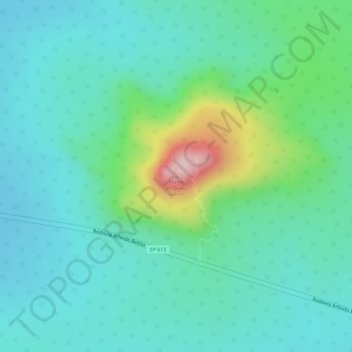
Name: Morro do Diabo topographic map, elevation, terrain.

Location: Morro do Diabo, Teodoro Sampaio, Região Imediata de Presidente Prudente, Região Geográfica Intermediária de Presidente Prudente, São Paulo, Southeast Region, Brazil (-22.51360 -52.31846 -22.51350 -52.31836)

Average elevation: 397 m

Minimum elevation: 336 m

Maximum elevation: 587 m

Gear up for your next adventure:

🎒Hiking Backpack - Lightweight and ergonomic backpacks for day hikes or multi-day treks
Camping Tent - Weather-resistant tents suitable for 2 to 6 people
🥾Waterproof Hiking Boots - Essential footwear for rugged terrain and wet Canadian trails
👟Leg Gaiters - Keep debris, mud, and snow out of your boots
🕶️Polarized Sunglasses - Reduces glare from snow and water at high elevations

As an Amazon Associate, this site earns from qualifying purchases at no extra cost to you.