

Mauá topographic map
Click on the map to display elevation.
Mauá
The city has a special characteristic hydrographic: not be crossed by any water course from another city, since, due to the high altitude, all streams that cross the territory of Mauá has their sources inside the city limits.
About this map
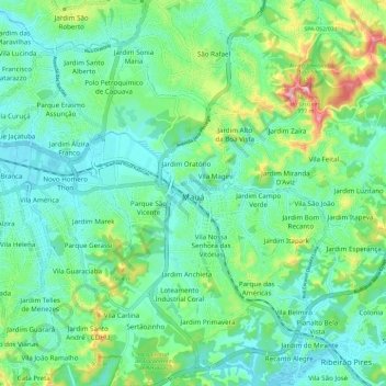
Name: Mauá topographic map, elevation, terrain.
Average elevation: 805 m
Minimum elevation: 746 m
Maximum elevation: 984 m
Other topographic maps
Click on a map to view its topography, its elevation and its terrain.
São Paulo
Brazil > São Paulo > Região Metropolitana de São Paulo > São Paulo
São Paulo is in Southeastern Brazil, in southeastern São Paulo State, approximately halfway between Curitiba and Rio de Janeiro. The city is on a plateau placed beyond the Serra do Mar (Portuguese for "Sea Range" or "Coastal Range"), itself a component of the vast region known as the Brazilian Highlands,…
Average elevation: 785 m
Sitio Borda da Mata
Brazil > São Paulo > Região Metropolitana de São Paulo > Franco da Rocha
Average elevation: 793 m

Praça Tenente Roberto Osaki
Brazil > São Paulo > Região Metropolitana de São Paulo > Osasco
Average elevation: 731 m
Praça Bartolomeu de Messina
Brazil > São Paulo > Região Metropolitana de São Paulo > São Paulo
Average elevation: 790 m