
Make a donation
Gear up for your next adventure:
As an Amazon Associate, this site earns from qualifying purchases at no extra cost to you.
Indaiatuba topographic map
Click on the map to display elevation.
Make a donation
Gear up for your next adventure:
As an Amazon Associate, this site earns from qualifying purchases at no extra cost to you.
Indaiatuba
Indaiatuba is a municipality in the state of São Paulo, Brazil. It is part of the Metropolitan Region of Campinas. The population is 256,223 (2020 est.) in an area of 311.5 km2 (120.3 sq mi). The elevation is 624 m (2,047 ft). The city's name derives from the Tupi language, which roughly translates to "gathering of palm trees". It is an important city in one of Brazil's main industrial regions.
Make a donation
Gear up for your next adventure:
As an Amazon Associate, this site earns from qualifying purchases at no extra cost to you.
About this map
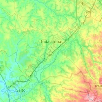
Name: Indaiatuba topographic map, elevation, terrain.
Average elevation: 619 m
Minimum elevation: 497 m
Maximum elevation: 916 m
Make a donation
Gear up for your next adventure:
As an Amazon Associate, this site earns from qualifying purchases at no extra cost to you.
Other topographic maps
Click on a map to view its topography, its elevation and its terrain.