Geolocate

Taraira topographic map

Click on the map to display elevation.

Taraira

Taraira es un municipio colombiano ubicado en el departamento del Vaupés. Se encuentra sobre la frontera con Brasil, localizado a 170 km al sur de Mitú, la capital departamental. Se encuentra a una altitud de 100 m s. n. m., registrando temperaturas entre los 27 y 30 °C. Con 2215 habitantes.

Wikipedia (CC-BY-SA 3.0)

About this map

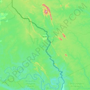
Name: Taraira topographic map, elevation, terrain.

Location: Taraira, Vaupés, RAP Amazonía, Colombia (-1.22767 -70.32747 -0.10835 -69.41799)

Average elevation: 128 m

Minimum elevation: 56 m

Maximum elevation: 638 m

Other topographic maps

Click on a map to view its topography, its elevation and its terrain.

Colombia

Colombia > Vaupés

Average elevation: 158 m

Puerto Asis

Colombia > Vaupés

Average elevation: 162 m

Querari

Colombia > Vaupés > Mitú

Average elevation: 190 m

Tiquie

Colombia > Vaupés > Mitú

Average elevation: 150 m

Puerto Colombia

Colombia > Vaupés > Yavaraté

Average elevation: 150 m

Vaupés

Colombia > Vaupés > Mitú

Average elevation: 172 m

Caruru

Colombia > Vaupés > Mitú

Average elevation: 187 m

Acaricuara

Colombia > Vaupés > Mitú > Acaricuara

Average elevation: 170 m

Mandi

Colombia > Vaupés > Mitú > Mandi

Average elevation: 200 m

Villa Fátima (Tipiaca

Colombia > Vaupés > Mitú

Average elevation: 165 m

Gear up for your next adventure:

🥾Hiking Shorts - Breathable shorts suitable for summer hikes
🧢Beanie Hat - Keep your head warm in cold weather
🥾Light Trekking Boots - Supportive boots for multi-day treks
🐕Hiking Dog Pack - Let your canine companion carry their own water and food
🕯️Camping Lantern - Illuminates your entire campsite with high-efficiency LEDs

As an Amazon Associate, this site earns from qualifying purchases at no extra cost to you.