Geolocate

Mandi topographic map

Click on the map to display elevation.

About this map

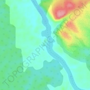
Name: Mandi topographic map, elevation, terrain.

Location: Mandi, Mitú, Vaupés, Colombia (1.07912 -70.73817 1.11912 -70.69817)

Average elevation: 200 m

Minimum elevation: 169 m

Maximum elevation: 282 m

Gear up for your next adventure:

🔭Compact Monocular - One-handed bird watching and trail spotting
🧴Sunscreen SPF - Broad-spectrum sunscreen for outdoor activities
🥾Approach Shoes - Shoes designed for climbing approaches and rugged trails
💧Reusable Water Bottle - Durable water bottles for hydration on trails
🧭GPS Handheld Device - Reliable GPS navigation for outdoor adventures

As an Amazon Associate, this site earns from qualifying purchases at no extra cost to you.