
Cádiz topographic map
Click on the map to display elevation.
Cádiz
The entire province of Cádiz has a Mediterranean climate, mostly Köppen Csa but also Csb in high altitude areas. Large differences in summer temperatures exist between the three official stations in Cádiz, Jerez, and Tarifa depending on position relative to the coastline. Tarifa is exceptionally mild for such a southerly place in Spain, meanwhile winter temperatures are mild throughout the province with less difference between localities than in summer. Average yearly rainfall is 521 mm (20.5 in) in Cádiz, 573 mm (22.6 in) in Jerez, and 603 mm (23.7 in) in Tarifa. This is comparable to much cloudier climates further north in Europe, in spite of the high number of sunshine hours in the province. The Cádiz region is also much wetter than the arid Almería province further east in Andalusia.
About this map
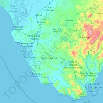
Name: Cádiz topographic map, elevation, terrain.
Location: Cádiz, Andalusia, Spain (36.00004 -6.44402 37.05245 -5.08677)
Average elevation: 127 m
Minimum elevation: -3 m
Maximum elevation: 1,610 m
Other topographic maps
Click on a map to view its topography, its elevation and its terrain.
Alhambra
Spain > Andalusia > Partido Judicial de Granada > Granada
During the reign of the Nasrid Dynasty, the Alhambra was transformed into a palatine city, complete with an irrigation system composed of aqueducts and water channels that provided water for the complex and for other nearby countryside palaces such as the Generalife. Previously, the old fortresses on the hill…
Average elevation: 759 m
Ventas de Zafarraya
Spain > Andalusia > Comarca de Alhama
Ventas de Zafarraya is in the municipality of Alhama de Granada, Granada, Spain. It has an area of 19.23 square kilometres (7.42 sq mi) and is at an elevation of 920 metres (3,020 ft). As of 2019 the population was 1,181. The postal code is 18125. The village is on the road from Alhama de Granada in the west…
Average elevation: 925 m
Málaga
Spain > Andalusia > Málaga-Costa del Sol > Málaga
Like many of the military fortifications that were constructed in Islamic Spain, the Alcazaba of Málaga featured a quadrangular plan. It was protected by an outer and inner wall, both supported by rectangular towers, between which a covered walkway led up the slope to the Gibralfaro (this was the only…
Average elevation: 215 m
Busquístar
Spain > Andalusia > Comarca de la Alpujarra Granadina > Busquístar
Average elevation: 1,260 m
Pico de Mulhacén
Spain > Andalusia > Partido Judicial de Órgiva > Trevélez
Mulhacén ([mulaˈθen]), with an elevation of 3,479 metres (11,414 ft), is the highest mountain in peninsular Spain and in all of the Iberian Peninsula. It is part of the Sierra Nevada range in the Penibaetic System. It is named after Abu'l-Hasan Ali, known as Muley Hacén in Spanish, the penultimate Muslim…
Average elevation: 3,070 m
Maroma
Spain > Andalusia > La Axarquía > Canillas de Aceituno
La Maroma, also known as Tejeda, at an altitude of 2069 m, is the highest peak of the Sierra de Tejeda, Penibaetic System, Spain. The summit is located in the region of Axarquía on the border between the provinces of Granada and Málaga.
Average elevation: 1,706 m
Pico de Mulhacén
Spain > Andalusia > Comarca de la Alpujarra Granadina > Trevélez
Mulhacén ([mulaˈθen]), with an elevation of 3,482 metres (11,424 ft), is the highest mountain in peninsular Spain and in all of the Iberian Peninsula. It is part of the Sierra Nevada range in the Penibaetic System. It is named after Abu'l-Hasan Ali, known as Muley Hacén in Spanish, the penultimate Muslim…
Average elevation: 3,070 m
Parque Natural Sierra de Tejeda, Almijara y Alhama
Spain > Andalusia > Comarca de Alhama
Average elevation: 754 m
Sierra Nevada
Spain > Andalusia > Comarca de la Alpujarra Granadina > Lanjarón
Average elevation: 2,223 m
Pico del Veleta
Spain > Andalusia > Comarca de la Alpujarra Granadina > Capileira
The IRAM 30m telescope is located on the slopes of Pico Veleta, at an elevation of 2920 m.
Average elevation: 2,998 m
Sierra de la Huerta del Abad
Spain > Andalusia > Sierra de Huelva > Aracena > Carboneras
Average elevation: 525 m
Castillo de Castellar
Spain > Andalusia > Campo de Gibraltar > Castellar de la Frontera > Castellar Viejo de la Frontera
Average elevation: 102 m
Jardines del Triunfo
Spain > Andalusia > Comarca de la Vega de Granada > Granada
Average elevation: 719 m
Cortijo ruinas
Spain > Andalusia > Comarca de la Alpujarra Granadina > Capileira
Average elevation: 2,246 m
El Encinarillo
Spain > Andalusia > Comarca de la Alpujarra Granadina > Válor
Average elevation: 1,717 m