Geolocate

Jasper topographic map

Click on the map to display elevation.

About this map

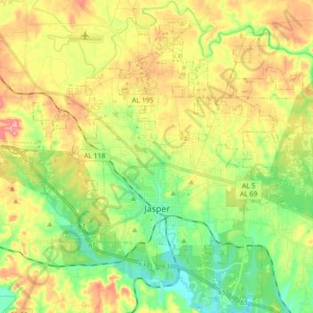
Name: Jasper topographic map, elevation, terrain.

Location: Jasper, Walker County, Alabama, United States (33.79029 -87.36190 33.91472 -87.20398)

Average elevation: 135 m

Minimum elevation: 80 m

Maximum elevation: 208 m

Other topographic maps

Click on a map to view its topography, its elevation and its terrain.

Cooner Mountain

United States > Alabama > Walker County

Average elevation: 197 m

Gibson Hill

United States > Alabama > Walker County

Average elevation: 171 m

Quinton

United States > Alabama > Walker County

Average elevation: 125 m

Boldo

United States > Alabama > Walker County

Average elevation: 130 m

Quinton

United States > Alabama > Walker County

Average elevation: 125 m

Gorgas

United States > Alabama > Walker County

Average elevation: 117 m

Goodsprings

United States > Alabama > Walker County

Average elevation: 141 m

Gear up for your next adventure:

🧼Travel Hand Sanitizer - Keep hands clean when water is scarce
🦌Outdoor Trail Camera - Monitor wildlife activity near your favorite spots
🔦LED Headlamp - Hands-free lighting for early morning starts or late finishes
🥾Lightweight Hiking Boots - Boots for comfort and mobility on long hikes
🧥Waterproof Pants - Keep dry during rainy hiking conditions

As an Amazon Associate, this site earns from qualifying purchases at no extra cost to you.