Geolocate

Goodsprings topographic map

Click on the map to display elevation.

About this map

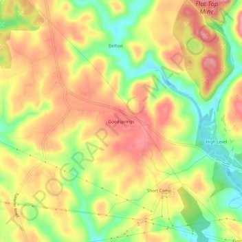
Name: Goodsprings topographic map, elevation, terrain.

Location: Goodsprings, Walker County, Alabama, 35560, United States (33.64900 -87.25167 33.68900 -87.21167)

Average elevation: 141 m

Minimum elevation: 78 m

Maximum elevation: 191 m

Other topographic maps

Click on a map to view its topography, its elevation and its terrain.

Cordova

United States > Alabama > Walker County

Average elevation: 110 m

Nauvoo

United States > Alabama > Walker County

Average elevation: 176 m

Oakman

United States > Alabama > Walker County

Average elevation: 128 m

Jasper

United States > Alabama > Walker County

Average elevation: 135 m

Carbon Hill

United States > Alabama > Walker County

Average elevation: 152 m

Jasper

United States > Alabama > Walker County

Average elevation: 135 m

Dora

United States > Alabama > Walker County

Average elevation: 123 m

Parrish

United States > Alabama > Walker County

Average elevation: 121 m

Gear up for your next adventure:

Camping Tent - Weather-resistant tents suitable for 2 to 6 people
🧦Thermal Socks - Warm socks for winter hiking or camping
🦶Hiking Shoe Insoles - Added support for high arches and long days on feet
🍽️Titanium Camping Spork - Ultralight and indestructible eating utensil
🦶Anti-Blister Balm - Prevents friction and hotspots during long ascents

As an Amazon Associate, this site earns from qualifying purchases at no extra cost to you.