Geolocate

Gorgas topographic map

Click on the map to display elevation.

About this map

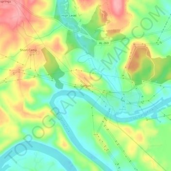
Name: Gorgas topographic map, elevation, terrain.

Location: Gorgas, Walker County, Alabama, 35560, United States (33.62928 -87.22806 33.66928 -87.18806)

Average elevation: 117 m

Minimum elevation: 69 m

Maximum elevation: 187 m

Other topographic maps

Click on a map to view its topography, its elevation and its terrain.

Cordova

United States > Alabama > Walker County

Average elevation: 110 m

Nauvoo

United States > Alabama > Walker County

Average elevation: 176 m

Oakman

United States > Alabama > Walker County

Average elevation: 128 m

Jasper

United States > Alabama > Walker County

Average elevation: 135 m

Carbon Hill

United States > Alabama > Walker County

Average elevation: 152 m

Jasper

United States > Alabama > Walker County

Average elevation: 135 m

Dora

United States > Alabama > Walker County

Average elevation: 123 m

Parrish

United States > Alabama > Walker County

Average elevation: 121 m

Gear up for your next adventure:

🧼Travel Hand Sanitizer - Keep hands clean when water is scarce
💡LED Camping Lantern - Illuminate your campsite with long-lasting lanterns
🧥Fleece Jacket - Warm and lightweight jacket for layering
🕶️Polarized Sunglasses - Reduces glare from snow and water at high elevations
🥾Lightweight Hiking Shoes - Comfortable shoes for day hikes

As an Amazon Associate, this site earns from qualifying purchases at no extra cost to you.