Geolocate

Quinton topographic map

Click on the map to display elevation.

About this map

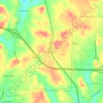
Name: Quinton topographic map, elevation, terrain.

Location: Quinton, Walker County, Alabama, 35011, United States (33.65205 -87.08666 33.69205 -87.04666)

Average elevation: 125 m

Minimum elevation: 83 m

Maximum elevation: 160 m

Other topographic maps

Click on a map to view its topography, its elevation and its terrain.

Cordova

United States > Alabama > Walker County

Average elevation: 110 m

Nauvoo

United States > Alabama > Walker County

Average elevation: 176 m

Oakman

United States > Alabama > Walker County

Average elevation: 128 m

Jasper

United States > Alabama > Walker County

Average elevation: 135 m

Carbon Hill

United States > Alabama > Walker County

Average elevation: 152 m

Jasper

United States > Alabama > Walker County

Average elevation: 135 m

Dora

United States > Alabama > Walker County

Average elevation: 123 m

Parrish

United States > Alabama > Walker County

Average elevation: 121 m

Gear up for your next adventure:

🥾Lightweight Hiking Shoes - Comfortable shoes for day hikes
🪑Ultralight Camping Stool - Compact seating for rest stops during long hikes
Camping Coffee Maker - Brew fresh coffee anywhere on the topographic map
🦯Trekking Poles - Reduced impact on joints for steep topographic climbs
🧭GPS Tracker - Track your location in remote areas safely

As an Amazon Associate, this site earns from qualifying purchases at no extra cost to you.