Geolocate

Gandara topographic map

Click on the map to display elevation.

About this map

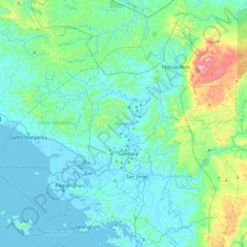
Name: Gandara topographic map, elevation, terrain.

Location: Gandara, Samar, Eastern Visayas, 6706, Philippines (11.94302 124.59984 12.17398 124.98039)

Average elevation: 126 m

Minimum elevation: -3 m

Maximum elevation: 817 m

Other topographic maps

Click on a map to view its topography, its elevation and its terrain.

Jiabong

Philippines > Samar

Average elevation: 48 m

Aguit-itan

Philippines > Samar > Calbayog

Average elevation: 5 m

Catbalogan

Philippines > Samar

Average elevation: 60 m

Guyam Island

Philippines > Samar > Catbalogan

Average elevation: 0 m

Hamlayan

Philippines > Samar > Ulayan

Average elevation: 6 m

Calbayog

Philippines > Samar

Average elevation: 55 m

Suribao River

Philippines > Samar

Average elevation: 268 m

Del Rosario

Philippines > Samar

Average elevation: 168 m

Bato

Philippines > Samar

Average elevation: 46 m

San Jose de Buan

Philippines > Samar > San Jose de Buan

Average elevation: 299 m

Ulot River

Philippines > Samar > Balagon

Average elevation: 105 m

Gear up for your next adventure:

🧣Evaporative Cooling Towel - Beat the heat during intense summer climbs
🥾Waterproof Trail Shoes - Shoes designed to handle wet terrain
Lightweight Camping Tent - Portable shelter optimized for Canadian backcountry camping
🧴Outdoor Sunscreen - High SPF protection for high-altitude UV exposure
🦌Outdoor Trail Camera - Monitor wildlife activity near your favorite spots

As an Amazon Associate, this site earns from qualifying purchases at no extra cost to you.