Geolocate

Catbalogan topographic map

Click on the map to display elevation.

About this map

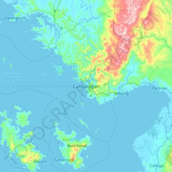
Name: Catbalogan topographic map, elevation, terrain.

Location: Catbalogan, Samar, Eastern Visayas, Philippines (11.61532 124.72295 11.93532 125.04295)

Average elevation: 60 m

Minimum elevation: -1 m

Maximum elevation: 490 m

Other topographic maps

Click on a map to view its topography, its elevation and its terrain.

Guyam Island

Philippines > Samar > Catbalogan

Average elevation: 0 m

Hamlayan

Philippines > Samar > Ulayan

Average elevation: 6 m

Gandara

Philippines > Samar

Average elevation: 126 m

Santa Margarita

Philippines > Samar

Average elevation: 41 m

Ulot River

Philippines > Samar > Balagon

Average elevation: 105 m

Suribao River

Philippines > Samar

Average elevation: 268 m

Gear up for your next adventure:

🧣Merino Neck Gaiter - Protects against wind, sun, and cold at high altitudes
Camping Groundsheet - Protect your tent from moisture and dirt
🧥Packable Rain Jacket - Breathable waterproof layer for unpredictable weather
🛶Kayak Accessories - Essential gear for safe and fun kayaking adventures
👟Sport Hiking Sandals - Breathable footwear for water crossings and camp rest

As an Amazon Associate, this site earns from qualifying purchases at no extra cost to you.