Geolocate

Jiabong topographic map

Click on the map to display elevation.

About this map

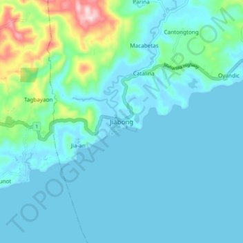
Name: Jiabong topographic map, elevation, terrain.

Location: Jiabong, Samar, Eastern Visayas, 6701, Philippines (11.72283 124.91019 11.80283 124.99019)

Average elevation: 48 m

Minimum elevation: -4 m

Maximum elevation: 335 m

Other topographic maps

Click on a map to view its topography, its elevation and its terrain.

Guyam Island

Philippines > Samar > Catbalogan

Average elevation: 0 m

Hamlayan

Philippines > Samar > Ulayan

Average elevation: 6 m

Gandara

Philippines > Samar

Average elevation: 126 m

Santa Margarita

Philippines > Samar

Average elevation: 41 m

Ulot River

Philippines > Samar > Balagon

Average elevation: 105 m

Suribao River

Philippines > Samar

Average elevation: 268 m

Gear up for your next adventure:

Camping Tent - Weather-resistant tents suitable for 2 to 6 people
🧭GPS Handheld Device - Reliable GPS navigation for outdoor adventures
🧣Merino Neck Gaiter - Protects against wind, sun, and cold at high altitudes
🔭Compact Monocular - One-handed bird watching and trail spotting
🧥Softshell Jacket - Windproof and breathable jacket for hiking

As an Amazon Associate, this site earns from qualifying purchases at no extra cost to you.