Geolocate

Little Ferry topographic map

Click on the map to display elevation.

About this map

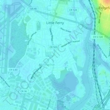
Name: Little Ferry topographic map, elevation, terrain.

Location: Little Ferry, Bergen County, New Jersey, 07643, United States (40.82855 -74.05398 40.85919 -74.02842)

Average elevation: 4 m

Minimum elevation: -3 m

Maximum elevation: 37 m

Other topographic maps

Click on a map to view its topography, its elevation and its terrain.

Ridgewood

United States > New Jersey > Bergen County

Average elevation: 56 m

Darlington

United States > New Jersey > Bergen County > Mahwah

Average elevation: 129 m

Drag Hill

United States > New Jersey > Bergen County > Mahwah

Average elevation: 252 m

Stag Hill

United States > New Jersey > Bergen County > Mahwah

Average elevation: 204 m

Green Hill

United States > New Jersey > Bergen County > Mahwah

Average elevation: 175 m

Fardale

United States > New Jersey > Bergen County > Mahwah

Average elevation: 124 m

Cragmere

United States > New Jersey > Bergen County > Mahwah

Average elevation: 136 m

Teterboro

United States > New Jersey > Bergen County > Teterboro

Average elevation: 12 m

Westwood

United States > New Jersey > Bergen County > Westwood > Westwood

Average elevation: 31 m

Gear up for your next adventure:

🥾Approach Boots - Comfortable boots for hiking and climbing approaches
🔦UV Flashlight - Detect minerals or specific insects in the dark
🧭GPS Tracker - Track your location in remote areas safely
🧴Bear Spray Holster - Quick-access carry for essential Canadian wilderness safety
🧦Crew Hiking Socks - Comfortable socks for long-distance hikes

As an Amazon Associate, this site earns from qualifying purchases at no extra cost to you.