
Nucla topographic map
Click on the map to display elevation.
About this map
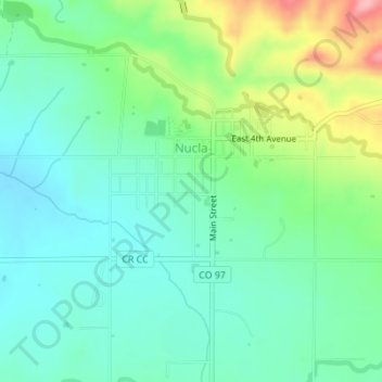
Name: Nucla topographic map, elevation, terrain.
Location: Nucla, Montrose County, Colorado, 81424, United States (38.25787 -108.56028 38.27484 -108.53652)
Average elevation: 1,767 m
Minimum elevation: 1,723 m
Maximum elevation: 1,877 m
Other topographic maps
Click on a map to view its topography, its elevation and its terrain.
Black Canyon of the Gunnison National Park
United States > Colorado > Montrose County
Average elevation: 2,225 m
Black Canyon of the Gunnison Wilderness
United States > Colorado > Montrose County
Average elevation: 2,163 m
Black Canyon of the Gunnison National Park
United States > Colorado > Montrose County
Average elevation: 2,225 m