
Fairview topographic map
Click on the map to display elevation.
About this map
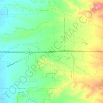
Name: Fairview topographic map, elevation, terrain.
Location: Fairview, Montrose County, Colorado, United States (38.46888 -107.82312 38.50888 -107.78312)
Average elevation: 1,876 m
Minimum elevation: 1,821 m
Maximum elevation: 1,967 m
Other topographic maps
Click on a map to view its topography, its elevation and its terrain.
Black Canyon of the Gunnison National Park
United States > Colorado > Montrose County
Average elevation: 2,225 m
Black Canyon of the Gunnison Wilderness
United States > Colorado > Montrose County
Average elevation: 2,163 m
Black Canyon of the Gunnison National Park
United States > Colorado > Montrose County
Average elevation: 2,225 m