
Kyustendil topographic map
Interactive map
Click on the map to display elevation.
About this map
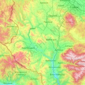
Name: Kyustendil topographic map, elevation, terrain.
Location: Kyustendil, Bulgaria (42.02087 22.35980 42.64896 23.52946)
Average elevation: 989 m
Minimum elevation: 309 m
Maximum elevation: 2,716 m
For the most part, the climate is transcontinental, but at higher altitudes it is mountainous. The main drainage river is Struma whose subsidiaries are the Treklyanska, Dragovishtitsa, Bistritsa, Slokoshtitsa, Novoselska, Dzherman and Rila rivers. Subterranean water levels are relatively high. Near the village of Kamenichka Skakavitsa, the Golemi dol river forms a 70-meter-high waterfall. The Dyakovo, Bersin, Drenov dol and Bagrentsi artificial lakes (dams) are chiefly used for irrigation purposes. Soil composition is most favorable for the traditionally developed fruit-growing.
Other topographic maps
Click on a map to view its topography, its elevation and its terrain.
River Park
Bulgaria > Sofia-City > Vitosha
River Park, Vitosha, Sofia City, Sofia-City, Bulgaria
Average elevation: 746 m
Graf Ignatievo
Graf Ignatievo, Maritsa, Plovdiv, 4198, Bulgaria
Average elevation: 191 m
Драгойна
Bulgaria > Plovdiv > Dragoynovo
Драгойна, Dragoynovo, Parvomai, Plovdiv, 4293, Bulgaria
Average elevation: 534 m
Panichishte
Panichishte, Sapareva Bania, Kyustendil, 2650, Bulgaria
Average elevation: 1,326 m