
Kremikovci topographic map
Interactive map
Click on the map to display elevation.
About this map
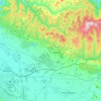
Name: Kremikovci topographic map, elevation, terrain.
Location: Kremikovci, Sofia City, Sofia-City, Bulgaria (42.67443 23.35298 42.86430 23.67867)
Average elevation: 738 m
Minimum elevation: 473 m
Maximum elevation: 1,681 m
Other topographic maps
Click on a map to view its topography, its elevation and its terrain.
River Park
Bulgaria > Sofia-City > Vitosha
River Park, Vitosha, Sofia City, Sofia-City, Bulgaria
Average elevation: 746 m
Svetovrachene
Bulgaria > Sofia-City > Novi Iskar
Svetovrachene, Novi Iskar, Sofia City, Sofia-City, 1222, Bulgaria
Average elevation: 525 m