
Make a donation
Gear up for your next adventure:
As an Amazon Associate, this site earns from qualifying purchases at no extra cost to you.
Municipio de Querétaro topographic map
Click on the map to display elevation.
Make a donation
Gear up for your next adventure:
As an Amazon Associate, this site earns from qualifying purchases at no extra cost to you.
About this map
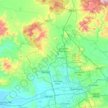
Name: Municipio de Querétaro topographic map, elevation, terrain.
Location: Municipio de Querétaro, Querétaro, Mexico (20.52353 -100.59654 20.92845 -100.32882)
Average elevation: 2,062 m
Minimum elevation: 1,765 m
Maximum elevation: 2,972 m
Make a donation
Gear up for your next adventure:
As an Amazon Associate, this site earns from qualifying purchases at no extra cost to you.
Other topographic maps
Click on a map to view its topography, its elevation and its terrain.
Make a donation
Gear up for your next adventure:
As an Amazon Associate, this site earns from qualifying purchases at no extra cost to you.
Make a donation
Gear up for your next adventure:
As an Amazon Associate, this site earns from qualifying purchases at no extra cost to you.
Cuidad Vive Oriente
Mexico > Querétaro > San Juan del Río > San Juan del Río
Average elevation: 1,990 m
Make a donation
Gear up for your next adventure:
As an Amazon Associate, this site earns from qualifying purchases at no extra cost to you.
Parque Queretaro 2000
Mexico > Querétaro > Municipio de Querétaro > Querétaro
Average elevation: 1,853 m
Make a donation
Gear up for your next adventure:
As an Amazon Associate, this site earns from qualifying purchases at no extra cost to you.
Make a donation
Gear up for your next adventure:
As an Amazon Associate, this site earns from qualifying purchases at no extra cost to you.