Geolocate

Bernal boulder topographic map

Click on the map to display elevation.

About this map

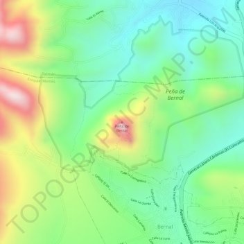
Name: Bernal boulder topographic map, elevation, terrain.

Location: Bernal boulder, Ezequiel Montes, Querétaro, Mexico (20.74955 -99.94595 20.74965 -99.94585)

Average elevation: 2,120 m

Minimum elevation: 1,962 m

Maximum elevation: 2,387 m

Other topographic maps

Click on a map to view its topography, its elevation and its terrain.

Villa Progreso

Mexico > Querétaro > Ezequiel Montes

Average elevation: 2,067 m

Bernal

Mexico > Querétaro > Ezequiel Montes

Average elevation: 2,102 m

Gear up for your next adventure:

🐕Hiking Dog Pack - Let your canine companion carry their own water and food
🥾Hiking Boots - Sturdy boots providing ankle support and traction on rugged trails
🦌Outdoor Trail Camera - Monitor wildlife activity near your favorite spots
💡Solar Camping Lamp - Eco-friendly lighting for campsites
🥾Waterproof Hiking Boots - Essential footwear for rugged terrain and wet Canadian trails

As an Amazon Associate, this site earns from qualifying purchases at no extra cost to you.