Geolocate

Jesus Maria topographic map

Click on the map to display elevation.

About this map

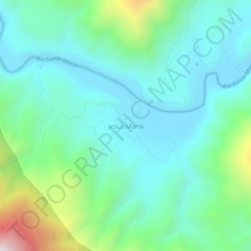
Name: Jesus Maria topographic map, elevation, terrain.

Location: Jesus Maria, Arroyo Seco, Querétaro, Mexico (21.46390 -99.72127 21.50390 -99.68127)

Average elevation: 800 m

Minimum elevation: 568 m

Maximum elevation: 1,590 m

Gear up for your next adventure:

🔨Vehicle Emergency Tool - Safety tool for remote road trips to trailheads
🧤Thermal Hiking Gloves - Grip-enhanced gloves for cold-weather altitude trekking
🥘Camping Cookware Set - Compact nesting pots and pans for trail cooking
Camping Tent - Weather-resistant tents suitable for 2 to 6 people
💡LED Headlamp - Hands-free illumination for night hiking and camping

As an Amazon Associate, this site earns from qualifying purchases at no extra cost to you.