Geolocate

Yingjiang topographic map

Click on the map to display elevation.

About this map

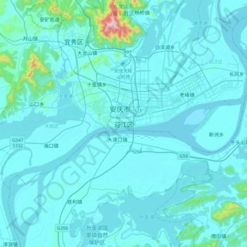
Name: Yingjiang topographic map, elevation, terrain.

Location: Yingjiang, Yingjiang District, Anqing City, Anhui, China (30.34772 116.89717 30.66772 117.21717)

Average elevation: 34 m

Minimum elevation: 0 m

Maximum elevation: 669 m

Other topographic maps

Click on a map to view its topography, its elevation and its terrain.

Lu'an

China > Anhui

Average elevation: 141 m

Chizhou

China > Anhui

Average elevation: 216 m

Chaohu City

China > Anhui

Average elevation: 33 m

Wusong

China > Anhui > Yi'an District

Average elevation: 24 m

Fanyang

China > Anhui > Fanchang District

Average elevation: 57 m

Yuzhong Subdistrict

China > Anhui > Huangshan City

Average elevation: 138 m

Jinghu District

China > Anhui

Average elevation: 8 m

Huashan District

China > Anhui

Average elevation: 20 m

Aofeng Subdistrict

China > Anhui > Xuanzhou District

Average elevation: 26 m

Gear up for your next adventure:

Camping Tent - Weather-resistant tents suitable for 2 to 6 people
🥾Waterproof Hiking Boots - Essential footwear for rugged terrain and wet Canadian trails
🥾Trail Running Boots - Durable shoes designed for trail running
🧦Hiking Socks - Moisture-wicking and comfortable socks for long hikes
🔭Outdoor Binoculars - Lightweight binoculars for birdwatching and hiking

As an Amazon Associate, this site earns from qualifying purchases at no extra cost to you.