Geolocate

Lu'an topographic map

Click on the map to display elevation.

About this map

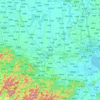
Name: Lu'an topographic map, elevation, terrain.

Location: Lu'an, Anhui, China (31.01064 115.36585 32.60853 117.24951)

Average elevation: 141 m

Minimum elevation: 4 m

Maximum elevation: 1,713 m

Other topographic maps

Click on a map to view its topography, its elevation and its terrain.

Yingjiang

China > Anhui

Average elevation: 34 m

Sucun

China > Anhui > Huangshan City

Average elevation: 266 m

Ningguo

China > Anhui > Ningguo > Xijin Subdistrict

Average elevation: 158 m

Guangde

China > Anhui > Guangde > 桐汭街道

Average elevation: 96 m

Gear up for your next adventure:

🛶Canoe Life Vest - Safety vest for water sports
🌬️Windproof Camp Stove - Efficient cooking even on exposed mountain peaks
💧Hydration Bladder - Hands-free hydration solution for long treks
💧Collapsible Water Bottle - Space-saving water bottle for outdoor activities
🥾Waterproof Hiking Shoes - Durable shoes for wet and rugged trails

As an Amazon Associate, this site earns from qualifying purchases at no extra cost to you.