Geolocate

Fanyang topographic map

Click on the map to display elevation.

About this map

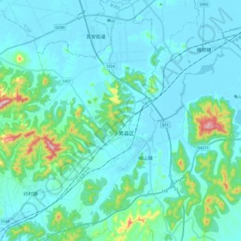
Name: Fanyang topographic map, elevation, terrain.

Location: Fanyang, Fanchang District, Wuhu, Anhui, China (31.01773 118.09316 31.20772 118.22400)

Average elevation: 57 m

Minimum elevation: 3 m

Maximum elevation: 436 m

Gear up for your next adventure:

🎒Fully Waterproof Backpack - Total protection for photography gear and electronics
💡Compact LED Flashlight - Powerful and portable flashlight for outdoor use
🧭Orienteering Kit - Tools for map reading and navigation in the wild
🛶Waterproof Dry Bags - Keep electronics and clothes dry during river crossings
🧴Waterproofing Spray - Restore the DWR coating on jackets and tents

As an Amazon Associate, this site earns from qualifying purchases at no extra cost to you.