Geolocate

Goshen topographic map

Click on the map to display elevation.

About this map

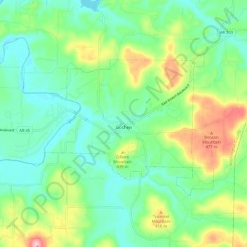
Name: Goshen topographic map, elevation, terrain.

Location: Goshen, Washington County, Arkansas, 72735, United States (36.07783 -94.05789 36.12712 -93.95309)

Average elevation: 396 m

Minimum elevation: 337 m

Maximum elevation: 529 m

Other topographic maps

Click on a map to view its topography, its elevation and its terrain.

Onda

United States > Arkansas > Washington County

Average elevation: 498 m

Hogeye

United States > Arkansas > Washington County

Average elevation: 414 m

Puddin Hill

United States > Arkansas > Washington County

Average elevation: 388 m

Winslow

United States > Arkansas > Washington County > Winslow

Average elevation: 562 m

Strickler

United States > Arkansas > Washington County

Average elevation: 486 m

Skylight

United States > Arkansas > Washington County

Average elevation: 476 m

Rhea

United States > Arkansas > Washington County > Rhea

Average elevation: 375 m

Fayetteville

United States > Arkansas > Washington County > Fayetteville

...yet I venture the assertion that nowhere in said country—or for that matter, in any part of the state—could be found a lovelier elevation, or a lovelier grove of graceful oaks, or a more commanding view, or, in fine, a spot better suited and adapted for the purposes designated than the one chosen for…

Average elevation: 404 m

Gear up for your next adventure:

📷Outdoor Action Camera - Capture high-elevation views and rugged adventures
🥾Mountain Hiking Boots - High-traction boots for rocky terrain
🦶Anti-Blister Balm - Prevents friction and hotspots during long ascents
🥾Waterproof Trail Shoes - Shoes designed to handle wet terrain
🚲MTB Frame Bag - Carry tools and maps directly on your bicycle frame

As an Amazon Associate, this site earns from qualifying purchases at no extra cost to you.