Geolocate

Onda topographic map

Click on the map to display elevation.

About this map

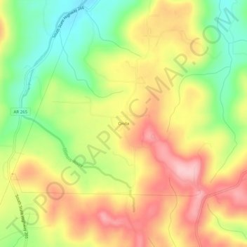
Name: Onda topographic map, elevation, terrain.

Location: Onda, Washington County, Arkansas, United States (35.84647 -94.31188 35.88647 -94.27188)

Average elevation: 498 m

Minimum elevation: 404 m

Maximum elevation: 587 m

Other topographic maps

Click on a map to view its topography, its elevation and its terrain.

Elm Springs

United States > Arkansas > Washington County

Average elevation: 380 m

Winslow

United States > Arkansas > Washington County > Winslow

Average elevation: 562 m

Lincoln

United States > Arkansas > Washington County

Average elevation: 436 m

Johnson

United States > Arkansas > Washington County

Average elevation: 384 m

Goshen

United States > Arkansas > Washington County

Average elevation: 396 m

Gear up for your next adventure:

🩹Moleskin Blister Pads - Direct protection for painful foot pressure points
👟Trail Running Shoes - Agile footwear for fast-paced topographic exploration
🛁Quick-Dry Microfiber Towel - Space-saving towel that dries rapidly on the move
🥾Waterproof Trail Shoes - Shoes designed to handle wet terrain
🧦Hiking Socks - Moisture-wicking and comfortable socks for long hikes

As an Amazon Associate, this site earns from qualifying purchases at no extra cost to you.