Geolocate

Strickler topographic map

Click on the map to display elevation.

About this map

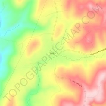
Name: Strickler topographic map, elevation, terrain.

Location: Strickler, Washington County, Arkansas, United States (35.81369 -94.33327 35.85369 -94.29327)

Average elevation: 486 m

Minimum elevation: 352 m

Maximum elevation: 590 m

Other topographic maps

Click on a map to view its topography, its elevation and its terrain.

Elm Springs

United States > Arkansas > Washington County

Average elevation: 380 m

Winslow

United States > Arkansas > Washington County > Winslow

Average elevation: 562 m

Lincoln

United States > Arkansas > Washington County

Average elevation: 436 m

Johnson

United States > Arkansas > Washington County

Average elevation: 384 m

Goshen

United States > Arkansas > Washington County

Average elevation: 396 m

Gear up for your next adventure:

🥾Trail Hiking Boots - Supportive boots for rough trails
🧢Hiking Hat - Sun-protective and breathable hats for long treks
🥾Trail Running Shoes - Lightweight and durable shoes for trail running
🧴Insect Repellent - Protect yourself from bugs during outdoor adventures
🧥Thermal Layer - Insulating layer for cold outdoor conditions

As an Amazon Associate, this site earns from qualifying purchases at no extra cost to you.