
Dovre topographic map
Interactive map
Click on the map to display elevation.
About this map
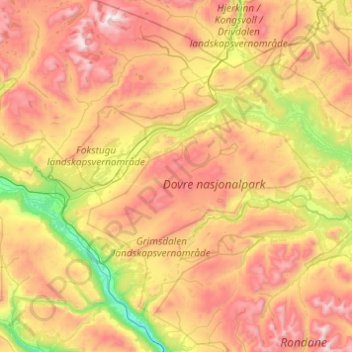
Name: Dovre topographic map, elevation, terrain.
Location: Dovre, Innlandet, Norway (61.88630 9.01028 62.34313 9.92820)
Average elevation: 1,195 m
Minimum elevation: 422 m
Maximum elevation: 2,260 m
The Dovre area is in a valley at fairly high altitude and isolated from the sea by mountain ranges, giving some rain shadow effect for Dovre. Dovre, with the town Dombås, has a subarctic climate (Dfc) with sparse precipitation. The driest season is late winter and spring, and the wettest season is summer. April on average sees just 18 millimetres (0.71 in) precipitaiton, while the wettest months July and August get almost four times as much.
Other topographic maps
Click on a map to view its topography, its elevation and its terrain.
Li
Norway > Innlandet > Skammestein
Li, Skammestein, Øystre Slidre, Innlandet, 2950, Norway
Average elevation: 774 m