Geolocate

Lom topographic map

Click on the map to display elevation.

About this map

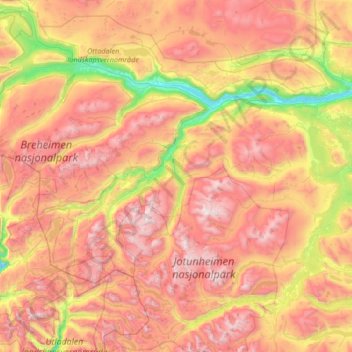
Name: Lom topographic map, elevation, terrain.

Location: Lom, Innlandet, Norway (61.39773 7.89565 62.03096 8.99269)

Average elevation: 1,327 m

Minimum elevation: 359 m

Maximum elevation: 2,441 m

Other topographic maps

Click on a map to view its topography, its elevation and its terrain.

Langedrag

Norway > Innlandet

Average elevation: 425 m

Li

Norway > Innlandet > Skammestein

Average elevation: 774 m

Gear up for your next adventure:

🧢Hiking Hat - Sun-protective and breathable hats for long treks
👟Leg Gaiters - Keep debris, mud, and snow out of your boots
🩹Compact First Aid Kit - Pre-packed essentials for common trail injuries
🧥Softshell Jacket - Windproof and breathable jacket for hiking
Lightweight Backpacking Tent - Compact tent for efficient hiking trips

As an Amazon Associate, this site earns from qualifying purchases at no extra cost to you.