
Tasmania topographic map
Interactive map
Click on the map to display elevation.
About this map
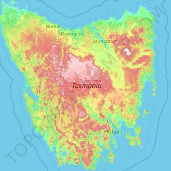
Name: Tasmania topographic map, elevation, terrain.
Location: Tasmania, Australia (-43.64304 144.60734 -40.64139 148.35910)
Average elevation: 220 m
Minimum elevation: -3 m
Maximum elevation: 1,524 m
The most mountainous region is the Central Highlands area, which covers most of the central western parts of the state. The Midlands located in the central east, is fairly flat, and is predominantly used for agriculture, although farming activity is scattered throughout the state. Tasmania's tallest mountain is Mount Ossa at 1,617 m (5,305 ft). Much of Tasmania is still densely forested, with the Southwest National Park and neighbouring areas holding some of the last temperate rain forests in the Southern Hemisphere. The Tarkine, containing Savage River National Park located in the island's far north west, is the largest temperate rainforest area in Australia covering about 3,800 square kilometres (1,500 sq mi). With its rugged topography, Tasmania has a great number of rivers. Several of Tasmania's largest rivers have been dammed at some point to provide hydroelectricity. Many rivers begin in the Central Highlands and flow out to the coast. Tasmania's major population centres are mainly situated around estuaries (some of which are named rivers).
Other topographic maps
Click on a map to view its topography, its elevation and its terrain.
Freycinet Peninsula
Freycinet Peninsula, Glamorgan-Spring Bay, Tasmania, Australia
Average elevation: 303 m
Adventure Bay
Adventure Bay, Kingborough, Tasmania, 7150, Australia
Average elevation: 110 m
Broad River
Australia > Tasmania > Ellendale
Broad River, Ellendale, Central Highlands, Tasmania, 7140, Australia
Average elevation: 709 m
Seymour Conservation Area
Australia > Tasmania > Seymour
Seymour Conservation Area, Seymour, Break O'Day, Tasmania, Australia
Average elevation: 19 m
Oyster Cove
Oyster Cove, Kingborough, Tasmania, Australia
Average elevation: 142 m
Cockle Creek
Australia > Tasmania > Recherche
Cockle Creek, Recherche, Huon Valley, Tasmania, Australia
Average elevation: 64 m
Launceston
Launceston, City of Launceston, Tasmania, 7250, Australia
Average elevation: 26 m
Anderson Island
Anderson Island, Flinders Council, Tasmania, Australia
Average elevation: 4 m
Lower Longley
Australia > Tasmania > Lower Longley
Lower Longley, Tasmania, Australia
Average elevation: 351 m
Breadalbane
Australia > Tasmania > Breadalbane
Breadalbane, Tasmania, 7212, Australia
Average elevation: 176 m
Reedy Marsh
Australia > Tasmania > Reedy Marsh
Reedy Marsh, Tasmania, Australia
Average elevation: 290 m
Randalls Bay
Australia > Tasmania > Randalls Bay
Randalls Bay, Tasmania, Australia
Average elevation: 49 m
Bathurst Harbour
Bathurst Harbour, Mount Beattie Track, Tasmania, Australia
Average elevation: 139 m