
Make a donation
Gear up for your next adventure:
As an Amazon Associate, this site earns from qualifying purchases at no extra cost to you.
Caramanico Terme topographic map
Click on the map to display elevation.
Make a donation
Gear up for your next adventure:
As an Amazon Associate, this site earns from qualifying purchases at no extra cost to you.
About this map
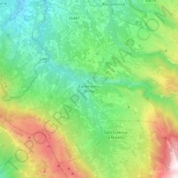
Name: Caramanico Terme topographic map, elevation, terrain.
Location: Caramanico Terme, Pescara, Abruzzo, 65023, Italy (42.09965 13.95884 42.21347 14.11947)
Average elevation: 954 m
Minimum elevation: 212 m
Maximum elevation: 2,651 m
Make a donation
Gear up for your next adventure:
As an Amazon Associate, this site earns from qualifying purchases at no extra cost to you.
Other topographic maps
Click on a map to view its topography, its elevation and its terrain.
Make a donation
Gear up for your next adventure:
As an Amazon Associate, this site earns from qualifying purchases at no extra cost to you.
Città Sant'Angelo
Italy > Abruzzo > Pescara > Città Sant'Angelo > Città Sant'Angelo
Average elevation: 123 m
Make a donation
Gear up for your next adventure:
As an Amazon Associate, this site earns from qualifying purchases at no extra cost to you.