Geolocate

Tancítaro topographic map

Click on the map to display elevation.

About this map
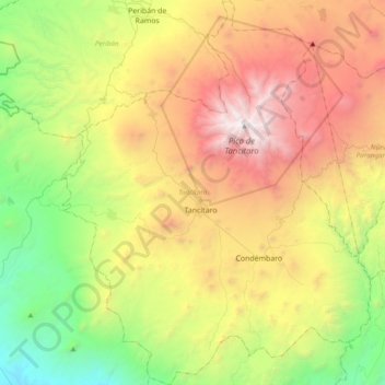
Name: Tancítaro topographic map, elevation, terrain.

Location: Tancítaro, Michoacán, Mexico (19.17302 -102.50047 19.53408 -102.19288)

Average elevation: 1,760 m

Minimum elevation: 331 m

Maximum elevation: 3,825 m

Other topographic maps

Click on a map to view its topography, its elevation and its terrain.
Zacapu

Mexico > Michoacán > Zacapu

Average elevation: 2,262 m

Villa Morelos

Mexico > Michoacán > Morelos > Villa Morelos

Average elevation: 2,352 m

La Yerbabuena

Mexico > Michoacán > Tlazazalca

Average elevation: 1,911 m

Jesús del Monte

Mexico > Michoacán > Morelia

Average elevation: 2,136 m

Chaparaco

Mexico > Michoacán > Zamora

Average elevation: 1,624 m

Zurumbeneo

Mexico > Michoacán > Zurumbeneo

Average elevation: 2,029 m

Ihuatzio

Mexico > Michoacán > Tzintzuntzan

Ihuatzio is located on the southeast of the Lake Pátzcuaro, about 8 kilometers southwest of the town center of Tzintzuntzan. Its average elevation is 2,052 meters above the sea level.

Average elevation: 2,052 m
Las Cieneguitas

Mexico > Michoacán > Tanhuato

Average elevation: 1,567 m

Gear up for your next adventure:

⛺Bushcraft Tarp - Versatile emergency shelter or gear protection
🦶Anti-Blister Balm - Prevents friction and hotspots during long ascents
🧦Hiking Liner Socks - Thin base layer to prevent friction and blisters
🔋Emergency Crank Radio - Weather alerts and power without needing batteries
🪑Insulated Seat Pad - Protect your seat from cold rocks and wet logs

As an Amazon Associate, this site earns from qualifying purchases at no extra cost to you.