Geolocate

Grumello del Monte topographic map

Click on the map to display elevation.

About this map

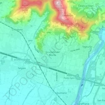
Name: Grumello del Monte topographic map, elevation, terrain.

Location: Grumello del Monte, Bergamo, Lombardy, 24064, Italy (45.60788 9.85579 45.66752 9.89117)

Average elevation: 245 m

Minimum elevation: 155 m

Maximum elevation: 608 m

Other topographic maps

Click on a map to view its topography, its elevation and its terrain.

Xino

Italy > Lombardy > Bergamo > Fonteno

Average elevation: 512 m

Tezzi Alti

Italy > Lombardy > Bergamo > Gandellino

Average elevation: 1,225 m

Bani

Italy > Lombardy > Bergamo > Ardesio

Average elevation: 1,064 m

Sogno

Italy > Lombardy > Bergamo > Torre de' Busi > San Marco

Average elevation: 842 m

Piangaiano

Italy > Lombardy > Bergamo

Average elevation: 557 m

Clanezzo

Italy > Lombardy > Bergamo > Ubiale Clanezzo

Average elevation: 401 m

Bani

Italy > Lombardy > Bergamo > Ardesio

Average elevation: 1,064 m

Borghetto

Italy > Lombardy > Bergamo > Burligo

Average elevation: 522 m

Tiglio

Italy > Lombardy > Bergamo > Zogno

Average elevation: 621 m

Lizzola

Italy > Lombardy > Bergamo

Average elevation: 1,517 m

Bondione

Italy > Lombardy > Bergamo > Lizzola

Average elevation: 1,457 m

Gear up for your next adventure:

🦯Trekking Poles - Reduced impact on joints for steep topographic climbs
Backpacking Tent - Lightweight tent for long-distance hiking trips
🧴Outdoor Sunscreen - High SPF protection for high-altitude UV exposure
💧Reusable Water Bottle - Durable water bottles for hydration on trails
🧣Evaporative Cooling Towel - Beat the heat during intense summer climbs

As an Amazon Associate, this site earns from qualifying purchases at no extra cost to you.