Geolocate

Bondione topographic map

Click on the map to display elevation.

About this map

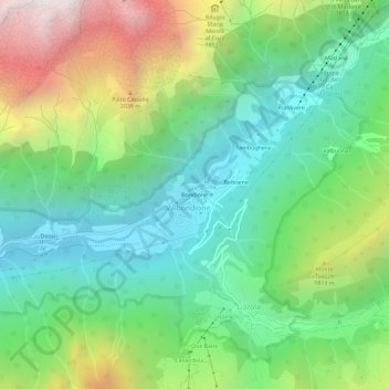
Name: Bondione topographic map, elevation, terrain.

Location: Bondione, Lizzola, Valbondione, Bergamo, Lombardy, Italy (46.01553 9.98681 46.05553 10.02681)

Average elevation: 1,457 m

Minimum elevation: 831 m

Maximum elevation: 2,711 m

Gear up for your next adventure:

🧴Sunscreen SPF - Broad-spectrum sunscreen for outdoor activities
🧥Ultralight Puffy Jacket - Maximum warmth that packs down to the size of an orange
🧭GPS Handheld Device - Reliable GPS navigation for outdoor adventures
💧Filtered Water Bottle - Safe drinking water on the go
🥽Outdoor Goggles - Protective eyewear for outdoor activities

As an Amazon Associate, this site earns from qualifying purchases at no extra cost to you.