Geolocate

Fair Lawn topographic map

Click on the map to display elevation.

About this map

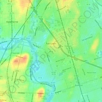
Name: Fair Lawn topographic map, elevation, terrain.

Location: Fair Lawn, Bergen County, New Jersey, 07410, United States (40.91775 -74.14817 40.95527 -74.08932)

Average elevation: 25 m

Minimum elevation: 8 m

Maximum elevation: 50 m

Other topographic maps

Click on a map to view its topography, its elevation and its terrain.

Ridgewood

United States > New Jersey > Bergen County

Average elevation: 56 m

Darlington

United States > New Jersey > Bergen County > Mahwah

Average elevation: 129 m

Drag Hill

United States > New Jersey > Bergen County > Mahwah

Average elevation: 252 m

Stag Hill

United States > New Jersey > Bergen County > Mahwah

Average elevation: 204 m

Green Hill

United States > New Jersey > Bergen County > Mahwah

Average elevation: 175 m

Fardale

United States > New Jersey > Bergen County > Mahwah

Average elevation: 124 m

Cragmere

United States > New Jersey > Bergen County > Mahwah

Average elevation: 136 m

Teterboro

United States > New Jersey > Bergen County > Teterboro

Average elevation: 12 m

Westwood

United States > New Jersey > Bergen County > Westwood > Westwood

Average elevation: 31 m

Gear up for your next adventure:

🚲Bike Repair Kit - Essential tools for on-trail mechanical issues
🧴Insect Repellent - Protect yourself from bugs during outdoor adventures
🧰Survival Kit - Essential gear for emergencies in the wilderness
🥾Hiking Leggings - Comfortable leggings for outdoor activities
🥾Trail Running Boots - Durable shoes designed for trail running

As an Amazon Associate, this site earns from qualifying purchases at no extra cost to you.