Make a donation
Gear up for your next adventure:
As an Amazon Associate, this site earns from qualifying purchases at no extra cost to you.
Fendels topographic map
Click on the map to display elevation.
Make a donation
Gear up for your next adventure:
As an Amazon Associate, this site earns from qualifying purchases at no extra cost to you.
About this map
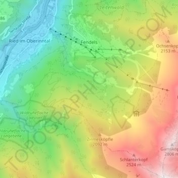
Name: Fendels topographic map, elevation, terrain.
Location: Fendels, Bezirk Landeck, Tyrol, 6528, Austria (47.01629 10.66348 47.06529 10.71968)
Average elevation: 1,663 m
Minimum elevation: 868 m
Maximum elevation: 2,850 m
Make a donation
Gear up for your next adventure:
As an Amazon Associate, this site earns from qualifying purchases at no extra cost to you.
Other topographic maps
Click on a map to view its topography, its elevation and its terrain.
Make a donation
Gear up for your next adventure:
As an Amazon Associate, this site earns from qualifying purchases at no extra cost to you.
Make a donation
Gear up for your next adventure:
As an Amazon Associate, this site earns from qualifying purchases at no extra cost to you.
Pettneu am Arlberg
Austria > Tyrol > Bezirk Landeck > Gemeinde Pettneu am Arlberg > Pettneu am Arlberg
Average elevation: 1,614 m
