
Make a donation
Gear up for your next adventure:
As an Amazon Associate, this site earns from qualifying purchases at no extra cost to you.
Pansy topographic map
Click on the map to display elevation.
Make a donation
Gear up for your next adventure:
As an Amazon Associate, this site earns from qualifying purchases at no extra cost to you.
About this map
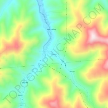
Name: Pansy topographic map, elevation, terrain.
Location: Pansy, Harlan County, Kentucky, 40830, United States (36.75509 -83.34879 36.79509 -83.30879)
Average elevation: 602 m
Minimum elevation: 387 m
Maximum elevation: 933 m
Make a donation
Gear up for your next adventure:
As an Amazon Associate, this site earns from qualifying purchases at no extra cost to you.
Other topographic maps
Click on a map to view its topography, its elevation and its terrain.
Lynch
United States > Kentucky > Harlan County
Lynch is located in eastern Harlan County at 36°57′54″N 82°55′00″W / 36.965133°N 82.916569°W / 36.965133; -82.916569 (36.965133, -82.916569), in the valley of Looney Creek. Lynch is the nearest city to Kentucky's highest point, Black Mountain (4,145 ft or 1,263 m). Sitting at an elevation…
Average elevation: 770 m