
Hida Mountains topographic map
Click on the map to display elevation.
About this map
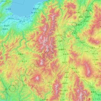
Name: Hida Mountains topographic map, elevation, terrain.
Location: Hida Mountains, Nagano Prefecture, Japan (35.57803 137.20413 36.98775 137.91069)
Average elevation: 964 m
Minimum elevation: -1 m
Maximum elevation: 3,132 m
Other topographic maps
Click on a map to view its topography, its elevation and its terrain.
Tokyo
The mainland portion of Tokyo lies northwest of Tokyo Bay and measures about 90 km (56 mi) east to west and 25 km (16 mi) north to south. The average elevation in Tokyo is 40 m (131 ft). Chiba Prefecture borders it to the east, Yamanashi to the west, Kanagawa to the south, and Saitama to the north. Mainland…
Average elevation: 22 m
Mount Fuji
Japan > Sunto County > Oyama
Mount Fuji (富士山, Fujisan, Japanese: [ɸɯꜜ(d)ʑisaɴ] (listen)), or Fugaku, located on the island of Honshū, is the highest mountain in Japan, with a summit elevation of 3,776.24 m (12,389 ft 3 in). It is the second-highest volcano located on an island in Asia (after Mount Kerinci on the island of…
Average elevation: 3,264 m
Hokkaido
As Japan's coldest region, Hokkaidō has relatively cool summers and icy/snowy winters. Most of the island falls in the humid continental climate zone with Köppen climate classification Dfb (hemiboreal) in most areas but Dfa (hot summer humid continental) in some inland lowlands. The average August…
Average elevation: 98 m
Yokohama
Yokohama has a total area of 437.38 km2 (168.87 sq mi) at an elevation of 5 metres (16 ft) above sea level. It is the capital of Kanagawa Prefecture, bordered to the east by Tokyo Bay and located in the middle of the Kantō plain. The city is surrounded by hills and the characteristic mountain system of the…
Average elevation: 23 m
Tokyo
The mainland portion of Tokyo lies northwest of Tokyo Bay and measures about 90 km (56 mi) east to west and 25 km (16 mi) north to south. The average elevation in Tokyo is 40 m (131 ft). Chiba Prefecture borders it to the east, Yamanashi to the west, Kanagawa to the south, and Saitama to the north. Mainland…
Average elevation: 22 m
Tokyo Bay
The shoal between Cape Futtsu in Chiba Prefecture and Cape Honmaku in Yokohama is known as Nakanose, and has a depth of 20 m (66 ft). North of this area the bay has a depth of 40 m (130 ft) and an uncomplicated underwater topography. Areas south of Nakanose are significantly deeper moving towards the Pacific…
Average elevation: 19 m
Hakone
Hakone is characterized by its rugged topography, featuring a mix of mountainous terrain, valleys, and volcanic landscapes. Nestled within the greater Fuji-Hakone-Izu National Park, Hakone's elevation varies dramatically, with peaks rising over 4,000 feet and low-lying areas near Lake Ashi, which sits at…
Average elevation: 722 m
Mount Yari
Two triangulation points were established at the summit. A milepost stone is fixed to the ground. As a reference point for the Geographical Survey Institute of Japan, it is of little importance and even on topographic maps, the summit of Yari-ga-take appears merely as an elevation point.
Average elevation: 2,606 m
Shinjuku
Naturally, most of Shinjuku is occupied by the Yodobashi Plateau, the most elevated portion of which extends through most of the Shinjuku Station area. The Kanda River runs through the Ochiai and Totsuka areas near sea level, but the Toshima Plateau also builds elevation in the northern extremities of Totsuka…
Average elevation: 35 m
Kyushu Region
The total area is 36,782.37 km2 (14,201.75 sq mi) which makes it the 37th largest island in the world. It is slightly larger than Taiwan's total area of 35,808 km2 (13,826 sq mi). The highest elevation is 1791 meters (5876 feet) on Mount Kujū.
Average elevation: 23 m
Izumi
Izumi is located in the southwestern part of Osaka Prefecture, about 25 km from the city center of Osaka and about 20 km from Kansai International Airport, forming a long and narrow city area (6.9 km east–west, 18.8 km north–south) from north to south. The total area of the city is the fifth largest in…
Average elevation: 142 m
Sanda
Sanda City is located in southeast Hyōgo Prefecture, about 25 kilometres (16 mi) to the north of the city of Kobe beyond the Rokkō Mountains and about 35 kilometres (22 mi) northwest of the city of Osaka. The highest elevation point in the city is 697 metres (2,287 ft) at Mt. Mine, and the lowest elevation…
Average elevation: 289 m
Saitama
The city is located 20 to 30 km north of central Tokyo, roughly at the center of the Kantō Plain. Situated in the southeast of Saitama Prefecture, the city is topographically comprised by lowlands and plateaus, at mostly less than 20 m above sea level, with no mountain ranges or hills within the city…
Average elevation: 13 m
Mount Fuji
Japan > Sunto County > Oyama
Mount Fuji (富士山, Fujisan, Japanese: [ɸɯꜜ(d)ʑisaɴ] (listen)), or Fugaku, located on the island of Honshū, is the highest mountain in Japan, with a summit elevation of 3,776.24 m (12,389 ft 3 in). It is the second-highest volcano located on an island in Asia (after Mount Kerinci on the island of…
Average elevation: 3,264 m
Fujinomiya
Fujinomiya is located in central Shizuoka Prefecture on an upland plateau on the foothills and lower slopes of Mount Fuji, with an altitude ranging from 35 to 3,336 m (115 to 10,945 ft). The average temperature is 15.6 °C (60.1 °F). Much of the city lies within the borders of Fuji-Hakone-Izu National Park.…
Average elevation: 789 m
Sendai
Sendai is located at lat. 38°16'05" north, long. 140°52'11" east. The city's area is 788.09 km2 (304.28 sq mi), and stretches from the Pacific Ocean to the Ōu Mountains, which are the east and west borders of Miyagi Prefecture. As a result, the city's geography is quite diverse. Eastern Sendai is a plains…
Average elevation: 185 m
Nagasaki
On the day of the nuclear strike (August 9, 1945) the population in Nagasaki was estimated to be 263,000, which consisted of 240,000 Japanese residents, 10,000 Korean residents, 2,500 conscripted Korean workers, 9,000 Japanese soldiers, 600 conscripted Chinese workers, and 400 Allied POWs. That day, the Boeing…
Average elevation: 44 m
Okinawa Island
The Motobu Peninsula in the north has limestone layers and karst development. In the center and south is mainly a Ryukyu limestone layer and mudstone. The topography is flat, there are few hills over 100 m (328 ft) with very few rivers. The subtropical rains accelerate erosion so there are many drainages and…
Average elevation: 14 m
Izumi
Izumi is located in the southwestern part of Osaka Prefecture, about 25 km from the city center of Osaka and about 20 km from Kansai International Airport, forming a long and narrow city area (6.9 km east–west, 18.8 km north–south) from north to south. The total area of the city is the fifth largest in…
Average elevation: 142 m
Sapporo
Sapporo is a city located in the southwest part of Ishikari Plain and the alluvial fan of the Toyohira River, a tributary stream of the Ishikari River. It is part of Ishikari Subprefecture. Roadways in the urban district are laid to make a grid plan. The western and southern parts of Sapporo are occupied by a…
Average elevation: 273 m
Takayama
Takayama (高山市, Takayama-shi) is a city located in Gifu Prefecture, Japan. As of 1 January 2019, the city had an estimated population of 88,473 in 35,644 households, and a population density of 41 persons per km2. The total area of the city was 2,177.61 square kilometres (840.78 sq mi) making it the…
Average elevation: 1,157 m
Yakushima
The bedrock of the island is granite, and as such it hosts no active volcanoes. It has an area of approximately 504.5 square kilometres (194.8 sq mi). The island is roughly circular in shape, with a circumference of 89 kilometres (55 mi) and a diameter of 28 kilometres (17 mi). The highest elevations on the…
Average elevation: 401 m
Uruma
Agena Castle is a gusuku located in the north of Agena district of Uruma, in former Gushikawa City. It was built on a base of Ryūkyūan limestone and occupies 8,000 square metres (86,000 ft2). Agena Castle sits at an altitude of 49 metres (161 ft), and is naturally protected by the Tengan River to the north.…
Average elevation: 12 m
Nagano
Nagano (長野市, Nagano-shi, pronounced [nagaꜜno ɕi]) is the capital and largest city of Nagano Prefecture, located in the Nagano Basin (Zenkoji Daira) in the central Chūbu region of Japan. Nagano is categorized as a core city of Japan. Nagano City is the highest prefectural capital in Japan, with an…
Average elevation: 828 m
Fukuchiyama
Fukuchiyama is located in northwestern Kyoto Prefecture, bordering Hyōgo Prefecture to the west. It is centered on the Fukuchiyama Basin formed by the Yura River, and is surrounded by mountains to the south, west, and east. It is located about 70 kilometers from downtown Osaka, 60 kilometers from Kyoto or…
Average elevation: 218 m
Tokyo
The mainland portion of Tokyo lies northwest of Tokyo Bay and measures about 90 km (56 mi) east to west and 25 km (16 mi) north to south. The average elevation in Tokyo is 40 m (131 ft). Chiba Prefecture borders it to the east, Yamanashi to the west, Kanagawa to the south, and Saitama to the north. Mainland…
Average elevation: 22 m
Mount Aso
Japan > Aso County > Minamiaso
With an elevation of 1,143 metres (3,750 ft)., Mount Aso has a climate that falls as humid continental (Köppen climate classification "Dfb"), with warm summers and cold winters. Precipitation is high throughout the year, which brings the area to have borderline subtropical characteristics as well. It is…
Average elevation: 1,254 m
Kamakura
The Kamakura shogunate era is called by historians the Kamakura period and, although its end is clearly set (Siege of Kamakura (1333)), its beginning is not. Different historians put Kamakura's beginning at a different point in time within a range that goes from the establishment of Yoritomo's first military…
Average elevation: 33 m
Nanyo
Nan'yo is located in the northern part of Okitama Basin in southern Yamagata Prefecture, with mountains to the north, east and west and the Mogami River forming its southern border. It is approximately 21 km from Yonezawa, 35 km from Yamagata city, 61 km from Fukushima, and 95 km from Sendai. The city has an…
Average elevation: 359 m
Machida
Machida is located in the Tama Hills of southern Tokyo Metropolis, bordered by Kanagawa Prefecture on the west, south, and east approximately 40 to 50 kilometers from the center of Tokyo. The highest point is Mount Kusato (elevation 364 meters) at the western end. There are few flatlands near Machida Station,…
Average elevation: 82 m
Mount Naka
Mount Naka (中岳, Naka-dake) is a mountain with an altitude of 3,084m located in the southern part of the Hida Mountains, which straddles Matsumoto in Nagano Prefecture and Takayama in Gifu Prefecture. This mountain is located in Chūbu-Sangaku National Park.
Average elevation: 2,627 m
Mount Fuji
Japan > Sunto County > Oyama
Mount Fuji (富士山, Fujisan, Japanese: [ɸɯꜜ(d)ʑisaɴ] (listen)), located on the island of Honshū, is an active stratovolcano in Japan, with a summit elevation of 3,776.24 m (12,389 ft 3 in). It is the tallest mountain in Japan, the second-highest volcano located on an island in Asia (after Mount…
Average elevation: 3,261 m