
Chanthaburi Province topographic map
Interactive map
Click on the map to display elevation.
About this map
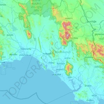
Name: Chanthaburi Province topographic map, elevation, terrain.
Location: Chanthaburi Province, Thailand (12.20921 101.68498 13.33607 102.53589)
Average elevation: 100 m
Minimum elevation: -2 m
Maximum elevation: 1,570 m
While the southern part of the province is on the shore of the Gulf of Thailand and thus is mostly coastal alluvial plains, the interior of the province is mountainous. The Chanthaburi Mountains in the north has the highest elevation in the province, the 1,675 m high Khao Soi Dao Tai peak. The main river of the province is the Chanthaburi River.
Other topographic maps
Click on a map to view its topography, its elevation and its terrain.
Ko Samui
Thailand > Surat Thani Province
Ko Samui, Surat Thani Province, Thailand
Average elevation: 75 m
Ko Phi Phi Leh
Ko Phi Phi Leh, Krabi Province, Thailand
Average elevation: 11 m
Erawan
Thailand > Kanchanaburi Province
Erawan, Kanchanaburi Province, 71250, Thailand
Average elevation: 348 m
Khao Rup Chang
Khao Rup Chang, Phawong, Songkhla Province, 90000, Thailand
Average elevation: 21 m
Nong Khai
Nong Khai, Pho Chai, Nong Khai Province, 43000, Thailand
Average elevation: 168 m
Mae Wang
Thailand > Chiang Mai Province
Mae Wang, Thung Satok, Chiang Mai Province, Thailand
Average elevation: 314 m
Mae Hia
Thailand > Chiang Mai Province
Mae Hia, San Phak Wan, Saraphi District, Chiang Mai Province, 50230, Thailand
Average elevation: 357 m
Ngio Don
Thailand > Sakon Nakhon Province
Ngio Don, Sakon Nakhon Province, Thailand
Average elevation: 190 m
Amphawa
Thailand > Samut Songkhram Province
Amphawa, Suan Luang, Bang Khonthi District, Samut Songkhram Province, 75110, Thailand
Average elevation: 5 m
Ban Luang Subdistrict Administrative Organization
Thailand > Phra Nakhon Si Ayutthaya Province
Ban Luang Subdistrict Administrative Organization, Sena District, Phra Nakhon Si Ayutthaya Province, 13110, Thailand
Average elevation: 5 m
Ban Na
Thailand > Nakhon Nayok Province
Ban Na, Phikun Ok, Nakhon Nayok Province, Thailand
Average elevation: 11 m
Ban Huai Pu
Thailand > Mae Hong Son Province > Ban Rai
Ban Huai Pu, Ban Rai, Mae Yuam, Mae Sariang, Mae Hong Son Province, 58110, Thailand
Average elevation: 249 m
Ban Muang Kung
Thailand > Chiang Mai Province
Ban Muang Kung, San Phak Wan, Saraphi District, Chiang Mai Province, 50230, Thailand
Average elevation: 314 m
Bang Duan Subdistrict Administrative Organization
Thailand > Samut Prakan Province
Bang Duan Subdistrict Administrative Organization, Bang Duan, Mueang Samut Prakan District, Samut Prakan Province, Thailand
Average elevation: 11 m
Phra Nakhon Si Ayutthaya District
Thailand > Phra Nakhon Si Ayutthaya Province
Phra Nakhon Si Ayutthaya District, Phra Nakhon Si Ayutthaya Province, 13000, Thailand
Average elevation: 5 m
Mae Raem
Thailand > Chiang Mai Province
Mae Raem, Chiang Mai Province, 50180, Thailand
Average elevation: 573 m
Ranong
Ranong, Pak Nam Tha Ruea, Ranong Province, Thailand
Average elevation: 103 m
Mae Chaem River
Thailand > Chiang Mai Province
Mae Chaem River, Hot District, Chiang Mai Province, 50240, Thailand
Average elevation: 877 m
Mae Sai district
Thailand > Chiang Rai Province
Mae Sai district, Wiang Phang Kham, Chiang Rai Province, Thailand
Average elevation: 525 m
Amphoe Rom Chamcha Fishing Pond
Thailand > Chiang Mai Province > Mae Hia > Ban Pa Chi
Amphoe Rom Chamcha Fishing Pond, Ban Pa Chi, Mae Hia, Nong Khwai, Chiang Mai Province, Thailand
Average elevation: 331 m
Phimai
Thailand > Nakhon Ratchasima Province
Phimai, Rang Ka Yai, Nakhon Ratchasima Province, 30110, Thailand
Average elevation: 155 m
Ban Khlong Nong Bon
Thailand > Samut Prakan Province > Racha Thewa Subdistrict Administrative Organization > Racha Thewa Subdistrict
Ban Khlong Nong Bon, Racha Thewa Subdistrict, Racha Thewa Subdistrict Administrative Organization, Bang Phli District, Samut Prakan Province, Thailand
Average elevation: 3 m
Ban Hin Lat
Ban Hin Lat, Non Sa-at, Khon Kaen Province, 40210, Thailand
Average elevation: 218 m
San Pa Muang Subdistrict
Thailand > Phayao Province > Mueang Phayao District
San Pa Muang Subdistrict, Ban Sang, Mueang Phayao District, Phayao Province, Thailand
Average elevation: 699 m
Ban Hin Sam Kon
Ban Hin Sam Kon, Phang-nga Province, Thailand
Average elevation: 49 m
Pai
Thailand > Mae Hong Son Province
Pai, Mae Hong Son Province, 58130, Thailand
Average elevation: 605 m
Pattaya
Pattaya, Nong Pla Lai, Chon Buri Province, 20210, Thailand
Average elevation: 28 m
Nong Pa Khrang
Nong Pa Khrang, Ton Pao, Saraphi District, 55520, Thailand
Average elevation: 307 m
Nong Phai
Thailand > Phetchabun Province
Nong Phai, Bua Watthana, Phetchabun Province, Thailand
Average elevation: 104 m
Map Ta Phut
Map Ta Phut, Thap Ma, Rayong Province, 21150, Thailand
Average elevation: 24 m
Ban Pak Khlong Decho
Thailand > Samut Prakan Province > Preng Subdistrict Administrative Organization > Preng Subdistrict
Ban Pak Khlong Decho, Preng Subdistrict, Preng Subdistrict Administrative Organization, Bang Bo District, Samut Prakan Province, Thailand
Average elevation: 3 m
Phra Nakhon Si Ayutthaya City Municipality
Thailand > Phra Nakhon Si Ayutthaya Province > Phra Nakhon Si Ayutthaya District
Phra Nakhon Si Ayutthaya City Municipality, Phra Nakhon Si Ayutthaya District, Phra Nakhon Si Ayutthaya Province, 13000, Thailand
Average elevation: 7 m
Bang Phra
Thailand > Nakhon Si Thammarat Province
Bang Phra, Nakhon Si Thammarat Province, Thailand
Average elevation: 2 m
Phang-nga
Thailand > Phang-nga Province > Phang-nga
Phang-nga, Phang-nga Province, Thailand
Average elevation: 57 m
Ban Huai Duea
Thailand > Nong Bua Lam Phu Province
Ban Huai Duea, Nong Bua Lam Phu Province, Thailand
Average elevation: 265 m
Lat Krabang District
Lat Krabang District, Bangkok, 10520, Thailand
Average elevation: 3 m