
Thank you for supporting this site ❤️
Make a donation
Make a donation
Gear up for your next adventure:
As an Amazon Associate, this site earns from qualifying purchases at no extra cost to you.
Mae Raem topographic map
Click on the map to display elevation.
Thank you for supporting this site ❤️
Make a donation
Make a donation
Gear up for your next adventure:
As an Amazon Associate, this site earns from qualifying purchases at no extra cost to you.
About this map
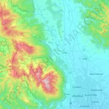
Name: Mae Raem topographic map, elevation, terrain.
Location: Mae Raem, Chiang Mai Province, 50180, Thailand (18.74876 98.75479 19.06876 99.07479)
Average elevation: 573 m
Minimum elevation: 299 m
Maximum elevation: 1,667 m
Thank you for supporting this site ❤️
Make a donation
Make a donation
Gear up for your next adventure:
As an Amazon Associate, this site earns from qualifying purchases at no extra cost to you.
Other topographic maps
Click on a map to view its topography, its elevation and its terrain.
Amphoe Rom Chamcha Fishing Pond
Thailand > Chiang Mai Province > Mae Hia > Ban Pa Chi
Average elevation: 331 m