Geolocate

Montello topographic map

Click on the map to display elevation.

About this map

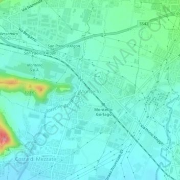
Name: Montello topographic map, elevation, terrain.

Location: Montello, Bergamo, Lombardy, 24060, Italy (45.66575 9.78364 45.67885 9.81505)

Average elevation: 233 m

Minimum elevation: 214 m

Maximum elevation: 319 m

Other topographic maps

Click on a map to view its topography, its elevation and its terrain.

Bani

Italy > Lombardy > Bergamo > Ardesio

Average elevation: 1,064 m

Clanezzo

Italy > Lombardy > Bergamo > Ubiale Clanezzo

Average elevation: 401 m

Bani

Italy > Lombardy > Bergamo > Ardesio

Average elevation: 1,064 m

Tiglio

Italy > Lombardy > Bergamo > Zogno

Average elevation: 621 m

Piangaiano

Italy > Lombardy > Bergamo

Average elevation: 557 m

Tezzi Alti

Italy > Lombardy > Bergamo > Gandellino

Average elevation: 1,225 m

Borghetto

Italy > Lombardy > Bergamo > Burligo

Average elevation: 522 m

Sogno

Italy > Lombardy > Bergamo > Torre de' Busi > San Marco

Average elevation: 842 m

Lizzola

Italy > Lombardy > Bergamo

Average elevation: 1,517 m

Bondione

Italy > Lombardy > Bergamo > Lizzola

Average elevation: 1,457 m

Gear up for your next adventure:

🧥Thermal Layer - Insulating layer for cold outdoor conditions
🧰Multitool Knife - Compact and versatile tool for outdoor use
🔦LED Flashlight - Powerful and long-lasting flashlight for camping and emergencies
🧴Insect Repellent - Protect yourself from bugs during outdoor adventures
🥾Waterproof Hiking Boots - Essential footwear for rugged terrain and wet Canadian trails

As an Amazon Associate, this site earns from qualifying purchases at no extra cost to you.