Geolocate

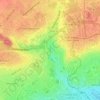
Bas de Venoix topographic map

Click on the map to display elevation.

About this map

Name: Bas de Venoix topographic map, elevation, terrain.

Location: Bas de Venoix, Caen, Calvados, Normandie, France métropolitaine, 14000, France (49.14751 -0.40787 49.18751 -0.36787)

Average elevation: 23 m

Minimum elevation: -1 m

Maximum elevation: 58 m

Other topographic maps

Click on a map to view its topography, its elevation and its terrain.
Manoir des Gens d'Armes

France > Normandie > Calvados > Caen

Average elevation: 21 m

Saint-Jean

France > Normandie > Calvados > Caen

Average elevation: 20 m

Pierre-Heuzé

France > Normandie > Calvados > Caen

Average elevation: 53 m

Hastings

France > Normandie > Calvados > Caen

Average elevation: 35 m

Chemin Vert

France > Normandie > Calvados > Caen

Average elevation: 57 m

La Maladrerie

France > Normandie > Calvados > Caen

Average elevation: 50 m

Vallée des Jardins

France > Normandie > Calvados > Caen

Average elevation: 48 m

Guérinière

France > Normandie > Calvados > Caen

Average elevation: 28 m

Lebisey

France > Normandie > Calvados > Caen

Average elevation: 44 m

Jardin des Plantes

France > Normandie > Calvados > Caen

Average elevation: 34 m

Gear up for your next adventure:

🧭GPS Handheld Device - Reliable GPS navigation for outdoor adventures
💧Hydration Pack - Hands-free hydration system for long hikes
🛏️Camping Sleeping Mat - Comfortable mats for sleeping outdoors
🥾Light Hiking Boots - Lightweight and comfortable boots for day hikes
🥾Hiking Gaiters - Protect legs and shoes from mud, snow, and debris

As an Amazon Associate, this site earns from qualifying purchases at no extra cost to you.