Geolocate

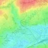
Chemin Vert topographic map

Click on the map to display elevation.

About this map

Name: Chemin Vert topographic map, elevation, terrain.

Location: Chemin Vert, Caen, Calvados, Normandie, France métropolitaine, 14000, France (49.18872 -0.41013 49.19587 -0.39478)

Average elevation: 57 m

Minimum elevation: 20 m

Maximum elevation: 81 m

Other topographic maps

Click on a map to view its topography, its elevation and its terrain.
Bas de Venoix

France > Normandie > Calvados > Caen

Average elevation: 23 m

Manoir des Gens d'Armes

France > Normandie > Calvados > Caen

Average elevation: 21 m

Vallée des Jardins

France > Normandie > Calvados > Caen

Average elevation: 48 m

Gear up for your next adventure:

🧥Softshell Jacket - Windproof and breathable jacket for hiking
⛺Family Camping Tent - Spacious tent suitable for family camping trips
🥾Mountaineering Boots - Supportive boots for climbing and high-altitude hiking
🥾Trekking Boots - Durable boots for long-distance trekking
🧼Biodegradable Camp Soap - Environmentally friendly cleaning for gear and body

As an Amazon Associate, this site earns from qualifying purchases at no extra cost to you.