
Division de Lower River topographic map
Interactive map
Click on the map to display elevation.
About this map
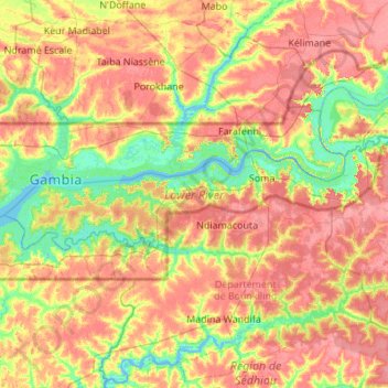
Name: Division de Lower River topographic map, elevation, terrain.
Location: Division de Lower River, Gambie (13.24081 -16.26273 13.55790 -15.17018)
Average elevation: 25 m
Minimum elevation: -4 m
Maximum elevation: 52 m
Other topographic maps
Click on a map to view its topography, its elevation and its terrain.
Dobang
Gambie > Division de West Coast
Dobang, Brikama, Division de West Coast, Gambie
Average elevation: 12 m
Kaur
Gambie > Division de Central River > Kaur
Kaur, Lower Saloum, Kuntaur, Division de Central River, Gambie
Average elevation: 9 m
Monom tbc
Gambie > Division de West Coast > Monom tbc
Monom tbc, Kombo North/Saint Mary, Brikama, Division de West Coast, Gambie
Average elevation: 36 m
Kerewan
Gambie > Division de North Bank
Kerewan, Division de North Bank, Gambie
Average elevation: 18 m
Kiang Central
Gambie > Division de Lower River
Kiang Central, Mansakonko, Division de Lower River, Gambie
Average elevation: 16 m
Niumi National Park
Gambie > Division de North Bank > Njongon
Niumi National Park, TAH 7, Essau, Njongon, Lower Niumi, Kerewan, Division de North Bank, Gambie
Average elevation: 6 m
Niani
Gambie > Division de Central River
Niani, Kuntaur, Division de Central River, Gambie
Average elevation: 28 m
Lower Niumi
Gambie > Division de North Bank
Lower Niumi, Kerewan, Division de North Bank, Gambie
Average elevation: 19 m
Essau
Gambie > Division de North Bank > Lower Niumi
Essau, Lower Niumi, Kerewan, Division de North Bank, Gambie
Average elevation: 4 m