
Lower Niumi topographic map
Interactive map
Click on the map to display elevation.
About this map
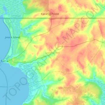
Name: Lower Niumi topographic map, elevation, terrain.
Location: Lower Niumi, Kerewan, Division de North Bank, Gambie (13.41965 -16.56027 13.59333 -16.28835)
Average elevation: 19 m
Minimum elevation: -2 m
Maximum elevation: 46 m
Other topographic maps
Click on a map to view its topography, its elevation and its terrain.
Kerewan
Gambie > Division de North Bank
Kerewan, Division de North Bank, Gambie
Average elevation: 18 m
Niumi National Park
Gambie > Division de North Bank > Njongon
Niumi National Park, TAH 7, Essau, Njongon, Lower Niumi, Kerewan, Division de North Bank, Gambie
Average elevation: 6 m
Essau
Gambie > Division de North Bank > Lower Niumi
Essau, Lower Niumi, Kerewan, Division de North Bank, Gambie
Average elevation: 4 m