Geolocate

Rutland topographic map

Click on the map to display elevation.

About this map

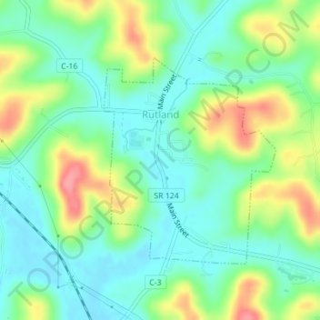
Name: Rutland topographic map, elevation, terrain.

Location: Rutland, Meigs County, Ohio, United States (39.03272 -82.13663 39.05014 -82.11788)

Average elevation: 202 m

Minimum elevation: 171 m

Maximum elevation: 262 m

Other topographic maps

Click on a map to view its topography, its elevation and its terrain.

Alfred

United States > Ohio > Meigs County

Average elevation: 228 m

Chester

United States > Ohio > Meigs County

Average elevation: 221 m

Hemlock Grove

United States > Ohio > Meigs County

Average elevation: 228 m

Gear up for your next adventure:

🕯️Camping Lantern - Illuminates your entire campsite with high-efficiency LEDs
🎒Hiking Daypack - Lightweight and durable backpacks for day trips and excursions
🥾Hiking Shoes - Durable and comfortable shoes for trail hiking
🥾Trail Hiking Shoes - Durable shoes designed for rugged trails
🦯Trekking Poles - Reduced impact on joints for steep topographic climbs

As an Amazon Associate, this site earns from qualifying purchases at no extra cost to you.