Geolocate

Alfred topographic map

Click on the map to display elevation.

About this map

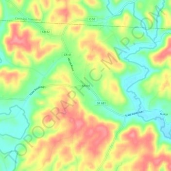
Name: Alfred topographic map, elevation, terrain.

Location: Alfred, Meigs County, Ohio, United States (39.15258 -81.94097 39.19258 -81.90097)

Average elevation: 228 m

Minimum elevation: 185 m

Maximum elevation: 273 m

Other topographic maps

Click on a map to view its topography, its elevation and its terrain.

Pomeroy

United States > Ohio > Meigs County

Average elevation: 209 m

Rutland

United States > Ohio > Meigs County

Average elevation: 202 m

Gear up for your next adventure:

🔋Lithium AA Batteries - Long-lasting power that performs in extreme cold
🚲Heavy Duty Bike Lock - Secure your bike at the trailhead or during stops
Camping Essentials - All-in-one gear for a comfortable camping trip
🚑Survival Whistle - Signal for help across long distances in mountains
🔦LED Headtorch - Bright and durable light for night activities

As an Amazon Associate, this site earns from qualifying purchases at no extra cost to you.