Geolocate

Osio Sotto topographic map

Click on the map to display elevation.

About this map

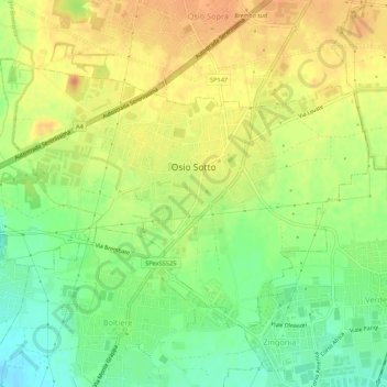
Name: Osio Sotto topographic map, elevation, terrain.

Location: Osio Sotto, Bergamo, Lombardy, 24046, Italy (45.60031 9.55957 45.62657 9.61350)

Average elevation: 179 m

Minimum elevation: 156 m

Maximum elevation: 198 m

Other topographic maps

Click on a map to view its topography, its elevation and its terrain.

Bani

Italy > Lombardy > Bergamo > Ardesio

Average elevation: 1,064 m

Clanezzo

Italy > Lombardy > Bergamo > Ubiale Clanezzo

Average elevation: 401 m

Bani

Italy > Lombardy > Bergamo > Ardesio

Average elevation: 1,064 m

Tiglio

Italy > Lombardy > Bergamo > Zogno

Average elevation: 621 m

Piangaiano

Italy > Lombardy > Bergamo

Average elevation: 557 m

Tezzi Alti

Italy > Lombardy > Bergamo > Gandellino

Average elevation: 1,225 m

Sogno

Italy > Lombardy > Bergamo > Torre de' Busi > San Marco

Average elevation: 842 m

Borghetto

Italy > Lombardy > Bergamo > Burligo

Average elevation: 522 m

Lizzola

Italy > Lombardy > Bergamo

Average elevation: 1,517 m

Bondione

Italy > Lombardy > Bergamo > Lizzola

Average elevation: 1,457 m

Gear up for your next adventure:

Camping Tent - Weather-resistant tents suitable for 2 to 6 people
🥤Collapsible Travel Cup - Saves space and weight in your mess kit
🥾Light Hiking Boots - Lightweight and comfortable boots for day hikes
🥘Camping Cookware Set - Compact nesting pots and pans for trail cooking
🩹Moleskin Blister Pads - Direct protection for painful foot pressure points

As an Amazon Associate, this site earns from qualifying purchases at no extra cost to you.